OverviewNearbyReviewsWin PrizesRecommended
Share to
Pico de la Zarza
2.3
 based on 105 reviews
Open year round, 24/7
Address:
Las Palmas de Gran Canaria, Canary Islands, SpainMap
What travelers say:
See all 6 photos
Recommendations Near Pico de la Zarza
Pico de la Zarza Reviews: Insider Insights and Visitor Experiences
Write a Review
 Trip.com
 (105 Reviews)TripAdvisor105 Reviews
You Might Also Like

Siam Park
5.8
4.6/517 Reviews
Free
Nearby Attractions
Oasis Wildlife Fuerteventura | Parque Natural de Jandia | Faro de Morro Jable | Playa de Cofete | Faro de Jandia | Costa Calma beach | Playa de Sotavento | Casa Winter | Risco Del Paso | Playa Esquinzo-Butihondom | SURFERS ISLAND - Surf-and Kitesurfschool Fuerteventura | Playa Esmeralda | Tortuga Fuerteventura | Fuerteventura Buceo Diving center | Playa de Mal Nombre | Playa del Viejo Rey | Playa de la Pared | Mojo Beach | Matas Bay Kite / Windsurf / Wing Surf Fuerteventura Exit 64 | Dive Pro Fuerte | OTRO MODO Surfcamp Hostel Fuerteventura | Juan Gomez Beach | Fuerteventura Diving | Pico de la Zarza | Jandía | Mirador de los canarios | Quad & Buggy Adventure Costa Calma | Shaman Fuerteventura Grow Shop | Playa del Matorral | Playa Salvaje
Popular Types of Attractions in Jandia
Outdoor Sports | Hiking | Water Sports | Hiking/Biking | Parks | City Parks | Zoos | Water Parks | Popular Spots | Nature | Beaches | Nature Reserves | Attractions | Sightseeing Tours | Water Activities | Hiking/Biking | Other Sightseeing Tours | Religious Sites | Churches and Cathedrals | Other Places of Worship | Architecture & Landmarks | Observation Decks | Monuments | Statues/Sculptures | Exhibition Centers | Museums | Art Museums | Military Sites | Lifestyle | Spas
Popular Restaurants in Jandia
Marabu | Curry House | El Bar de Marko y Moni | Kape | Fuerte Action Cafe | B Side Cafe Fuerteventura | Ristorante Pizzeria L' Italiano | L'Aperipizza | La Bodega de Jandia | Tasca Dos Jotas | Restaurante la Puntilla Casa Menso | The Boot & Ball Ventura | Ristorante Arena | La Fonda | Restaurante China Town Jandia | Restaurante Terraza del Gato | Charly Restaurante | Beach House Shop | Tony's Non Solo Cafe | Pizzería Faufal | COCO BANANA | Mirador de Sotavento | La Laja | Avenida del Mar | Waikiki Restaurant Snack-bar Grill | Ramon Hernandez Sosa | Mis Abuelos | Pastelerias y Confiterias | Restaurant Pizzeria Hawaii | Chinatown
Popular Destinations
Monte Carlo Travel | El Nido Travel | Odunpazari Travel | Surigao Travel | Rouse Hill Travel | Sapporo Travel | New Delhi Travel | Nice Travel | Virginia Beach Travel | Kathmandu Travel | Kota Kinabalu Travel | Moalboal Travel | Incheon Travel | Haining Travel | Sousse Travel | Rovinj Travel | Gyeonggi-do Travel | Tillamook Travel | San Teodoro Travel | Russellville Travel | Manado Travel | Bernardsville Travel | Lago Argentino Department Travel | Highlands County Travel | Cleveland County Travel | Provence Travel | Harbin Travel | Subiaco Travel | San Antonio de Areco Travel
Recommended Attractions at Popular Destinations
Bangkok attraction near me | Manila attraction near me | Tokyo attraction near me | Taipei attraction near me | Hong Kong attraction near me | Seoul attraction near me | Los Angeles attraction near me | Kuala Lumpur attraction near me | Shanghai attraction near me | New York attraction near me | Shenzhen attraction near me | Osaka attraction near me | London attraction near me | Singapore attraction near me | Guangzhou attraction near me | San Francisco attraction near me | Beijing attraction near me | Macau attraction near me | Bali attraction near me | Paris attraction near me | Jakarta attraction near me | Ho Chi Minh City attraction near me | Orlando attraction near me | Phuket attraction near me | Toronto attraction near me | Chicago attraction near me | Cebu attraction near me | Seattle attraction near me | Istanbul attraction near me | Fukuoka attraction near me
Popular Ranked Lists
Popular Luxury Hotels Near Balikliova | Popular Family-friendly Attractions Near Quwo | Popular Family-friendly Attractions Near Huguan | Top 16 Local Restaurants in Edinburgh | Top 10 Local Restaurants in Phan Thiet | Popular Family-friendly Attractions Near Hegang | Popular Luxury Hotels Near Comal County | Top 20 Local Restaurants in Zhengzhou | Top 16 Local Restaurants in Amsterdam | Top 7 Premium Hotels in Beihai | Popular Family-friendly Attractions Near Wutai | Popular Family-friendly Attractions Near Daguan | Top 3 Premium Hotels in Daocheng Yading | Top 19 Local Restaurants in Manchester | Top 21 Local Restaurants in George Town | Popular Luxury Hotels Near Holambra | Popular Luxury Hotels Near Centre County | Popular Luxury Hotels Near Mithatpasa Mahallesi | Popular Luxury Hotels Near Ancenis-Saint-Gereon | Top 21 Local Restaurants in Zhangjiajie | Popular Luxury Hotels in Reykjavik | Popular Premium Hotels in Parras de la Fuente | Top 10 Luxury Hotels in London metropolitan area | Popular Family-friendly Attractions Near Funing | Top 20 Local Restaurants in Taiyuan | Popular Family-friendly Attractions Near Horqin Left Middle Banner | Popular Family-friendly Attractions Near Luodian | Top 16 Local Restaurants in Hohhot | Popular Family-friendly Attractions Near Ongniud Banner
Popular Travel Types
More Things To Do in Jandia
Fuerteventura Sailing Trip from Morro Jable | South Fuerteventura Jeep Tour to Cofete Beach | Fuerteventura South Exclusive Tour | Fuerteventura Deluxe Catamaran Tour with meals and drinks | Fuerteventura: Day at Sea on a Sailing Catamaran with Lunch and Drinks | Odyssee 3: The Glass Bottom Boat Tour in Fuerteventura | Fuerteventura: PANORAMA island GRAND tour. | Buggy Safari In Costa Calma | 4X4 Safari: Jandía Natural Park and Cofete | 4x4 Jeep Safari Tour in Cofete Beach and Villa Winter | Discover the real Fuerteventura: extraordinary paths surrounded by nature | Europe 35 countries eSIM 4G/5G high-speed network QR code | Europe 33 eSIM|Unlimited 4G/5G High Speed Data | Global (66 Countries) eSIM Data Package (QR Code) | Europe 20 countries eSIM 4G/5G high-speed network QR code | European countries + Turkey eSIM | Unlimited Traffic Days optional QR code | Lobos Island - The dolphin route | Tastes of Fuerteventura Minivan VIP Tour | eSIM New Europe 33 countries by Gohub | EE33BC | Buggy Safari In Corralejo Since 2003 | Global eSIM J series in multiple regions | High-speed data for tourism and business Internet, unlimited data, optional days, QR code | Fuerteventura’s Cultural Gems: A Walking Tour | Global multi-region B series eSIM|Universal in 54 countries Travel and business Internet access Optional unlimited data Optional days QR code | Global eSIM 4G/5G high-speed network QR code | Portugal, Spain eSIM Data Plan QR Code | Spain eSIM 4G/5G high-speed network QR code | 2,5-hour Segway Tour around Caleta de Fuste in Fuerteventura | Europe 52 countries eSIM 4G/5G high-speed network QR code | Lobos Island Half-Day Sailing Tour with Lunch | 3-Hour Small-Group Sailing Tour around the Lobos Island
Payment Methods
Our Partners
Copyright © 2024 Trip.com Travel Singapore Pte. Ltd. All rights reserved
Site Operator: Trip.com Travel Singapore Pte. Ltd.
Site Operator: Trip.com Travel Singapore Pte. Ltd.
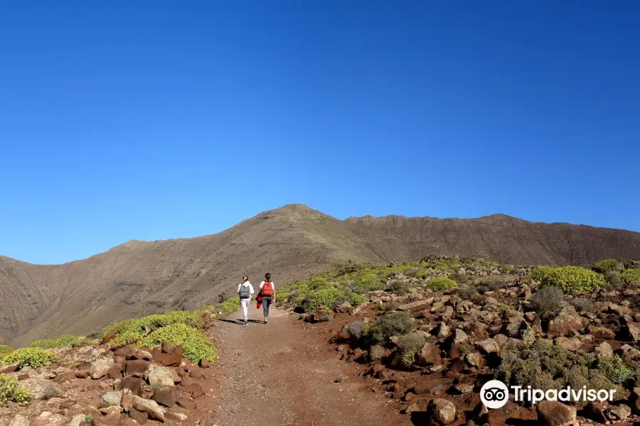
It's the Highest Mountain on Fuertevntura
Pico de la Zarza rises 812 metres or 2860 feet above sea-level. It is a simple walk with a 4x4 track leading 80% of the way and the rest of the trail is very well marked out (large stones define the f...
It's the Highest Mountain on Fuertevntura
Pico de la Zarza rises 812 metres or 2860 feet above sea-level. It is a simple walk with a 4x4 track leading 80% of the way and the rest of the trail is very well marked out (large stones define the f...
Amazing!
Great climb with stunning views! Despite it being cloudy at the peak it was still well worth it. Took us about 3 hrs there and back (including breaks and a stop at the top). For anyone who’s unsure ...
Amazing!
Great climb with stunning views! Despite it being cloudy at the peak it was still well worth it. Took us about 3 hrs there and back (including breaks and a stop at the top). For anyone who’s unsure ...
Stunning lookout!
Amazing trail walk/run. About 6.5km & 733m of ascent to top. Path consists mainly of loose gravel/dirt, be sure to take water