OverviewBookNearbyReviewsWin PrizesRecommended
Share to
Gull Island
海鷗島3.7
167 Reviews
Open year round, 24/7
Recommended sightseeing time:2-3 hours
Address:
East Side of Shilou Town, Panyu District, Guangzhou CityMap
Phone020-84651656
What travelers say:
在海鸥岛一条海鸥公里贯穿南北,还有环岛公路绕岛一周,东西像鱼骨似的排列着条条小路,串联着村落和片片田野。我们沿着环湖路自北向南。一路上看到欢声笑语环岛游览的人们。海鸥岛,一个典型的河流冲积而成内河岛屿,目前全岛总共有两万名多岛民。岛内河网交错,小桥纵横,鱼塘与水稻相连,芭蕉与绿树一色。这儿土地肥沃,气候温暖,四季不同景,最赋有意境的当是春秋两季,春天晨曦中的田野是凝固恬静地,当太阳升高的时候,绿从四面八方袭来,一片生机昂然的景象。
More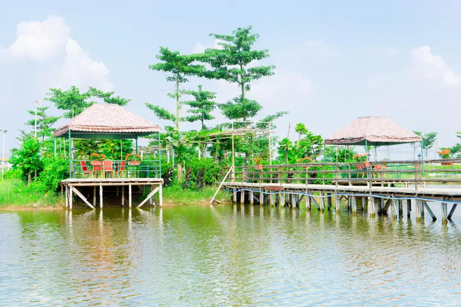
See all 12 photos
Saved by 8
Gull Island Highlights: Must-See Features and Attractions
Some information may have been translated by Google Translate
Located opposite to the Lianhua Mountain in Panyu District, Haiou Island is an original ecological island that has not yet been opened. The main industry on the island is agriculture. Residents have retained their original farming practices: planting rice, bananas, raising fish and so on. The island is a favorite weekend destination for the residents of Guangzhou. At the northern tip of Haiou Island, the Great Bridge of Haiou connects the Lianhuashan Waterway and the land outside the island. A 13 kilometer-long highway runs through the entire island from north to south. On Haiou Island, cycling is a good way to see around. While feeling the sea breeze, one can enjoy the scenery on both sides, which is very satisfying.
Recommendations Near Gull Island
Gull Island Reviews: Insider Insights and Visitor Experiences
Some reviews may have been translated by Google TranslateWrite a Review
/5
Excellent ReviewsAll (167)
Latest
With Photos (111)
Positive Reviews (86)
Negative Reviews (3)
- 1
- 2
- 3
- 4
- 34
You Might Also Like
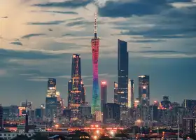
Canton Tower
8.6
4.5/533907 Reviews
From AU$ 31.05
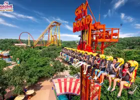
Chimelong Paradise
8.1
4.7/521848 Reviews
From AU$ 38.30
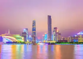
Pearl River Night Cruise
8.0
4.5/57685 Reviews
-AU$ 6.21
From AU$ 20.29
Guangdong Science Center
7.4
4.6/59049 Reviews
From AU$ 12.42
Nearby Attractions
Chimelong Safari Park | Guangzhou Chimelong Tourist Resort | Canton Tower | Chimelong International Circus | Chimelong Paradise | Pearl River Night Cruise | Shamian Island | Guangdong Science Center | Chimelong Water Park | Chimelong Bird Park | Chen Clan Ancestral Hall | Guangzhou Zoo | Guangdong Museum | Grandview Mall | Grandview Aquarium | Baiyun Mountain | NANYUE KING MUSEUM | Guangzhou Tower Ferris Wheel | Sun Yat-Sen Memorial | Guangzhou Big Buddha Temple | Shangxiajiu Pedestrian Street | Pearl River Night Cruise Tianzi Pier | South China Botanical,Chinese Academy of Sciences | Shawan Town | Yuexiu Park | Sacred Heart Cathedral | Beijing Road Pedestrian Street | Yongqing Lane | Lychee Bay Scenic Area | 【廣州】李昊《9862》音樂會
Popular Types of Attractions in Guangzhou
Parks | City Parks | Children's Play Areas | Water Parks | Architecture & Landmarks | Squares | Featured Neighborhoods | Historical Architectures | Lifestyle | Libraries | Campgrounds | Resorts | Religious Sites | Memorial Temples | Churches and Cathedrals | Temples | Exhibition Centers | Fine Art Galleries | Museums | Memorial Halls | Nature | Mountains | Beaches | Forests | Fitness | Badminton Courts | Stadiums | Basketball Courts | Historic Sites | Historical Sites
Popular Restaurants in Guangzhou
Caffe Mondo | Yue Chinese Restaurant (Sheraton Guangzhou Hotel) | Yue Jing Xuan | Lingnan House | Panda All Day Dining | Jiang by Chef Fei | BingSheng Private Kitchen (Tianhe East Road) | Penhouse | BingSheng Mansion | ZI ZHOU LOU | Howard’s Gourmet Guangzhou | Yue Creative Cantonese Cuisine | white tiger | Zhongbo Art hotel·Dian Dou De (Ju Fu Lou) | Lai Heen | Suyab Courtyard・Pickmoon Gourmet | Li Chateau | Lai Wan | Li Yuan Restaurant (YiAn Plaza) | CHAO YUE | Tian bar | Rêver | Ebony | Le Grill @ Sofitel Guangzhou Sunrich | Skov River Resort · All-day restaurant | Char Bar & Grill | Atrium | Hong Mian @ The Westin Guangzhou | Guangzhou Restaurant (Wenchang South Road) | Catch Restaurant
Popular Destinations
Los Angeles Travel | Traralgon Travel | Montauban Travel | Canberra Travel | Malaysia Travel | Liloan Travel | Hahndorf Travel | Darwin Travel | Cook Islands Travel | Zhuhai Travel | Port Douglas Travel | Kunming Travel | Maldives Travel | Buenos Aires Travel | United States Travel | Caulfield Travel | Tehran Travel | City of Los Angeles Travel | Chiang Rai Travel | Toyota Travel | Windham County Travel | Wangjiang Travel | Nanling Travel | Chowan County Travel | North-West District Travel | Campbell County Travel | Guadalupe County Travel | Rishikesh Travel | Boljoon Travel
Recommended Attractions at Popular Destinations
Bangkok attraction near me | Manila attraction near me | Tokyo attraction near me | Taipei attraction near me | Hong Kong attraction near me | Seoul attraction near me | Los Angeles attraction near me | Kuala Lumpur attraction near me | Shanghai attraction near me | New York attraction near me | Shenzhen attraction near me | Osaka attraction near me | London attraction near me | Singapore attraction near me | Guangzhou attraction near me | San Francisco attraction near me | Beijing attraction near me | Macau attraction near me | Bali attraction near me | Paris attraction near me | Jakarta attraction near me | Ho Chi Minh City attraction near me | Orlando attraction near me | Phuket attraction near me | Toronto attraction near me | Chicago attraction near me | Cebu attraction near me | Seattle attraction near me | Istanbul attraction near me | Dallas attraction near me
Popular Ranked Lists
Popular Premium Hotels in Wulanmaodu | Popular Family-friendly Attractions Near Beichuan | Popular Family-friendly Attractions Near Qingyuan | Popular Premium Hotels Near Calcasieu Parish | Top 16 Local Restaurants in Amsterdam | Popular Family-friendly Attractions Near Huoshan | Popular Family-friendly Attractions Near Shuangfeng | Popular Luxury Hotels Near Plymouth County | Popular Family-friendly Attractions Near Hejiang | Top 4 Premium Hotels in Huangshan Scenic Area | Top 20 Local Restaurants in Las Vegas | Top 10 Local Restaurants in Valletta | Popular Family-friendly Attractions Near Fuliang | Top 7 Premium Hotels in Liangshan Prefecture | Top 22 Local Restaurants in Yangzhou | Popular Family-friendly Attractions Near Zhangwu | Popular Family-friendly Attractions Near Jiexi | Popular Premium Hotels Near Awat | Top 13 Premium Hotels in Emeishan | Popular Family-friendly Attractions Near Sanhe | Top 7 Premium Hotels in Yangcheng Lake | Popular Family-friendly Attractions Near Long'an | Popular Luxury Hotels Near Gemeinde Kapelln an der Perschling | Top 4 Bars in Phi Phi Islands | Top 19 Local Restaurants in Singapore | Top 20 Local Restaurants in Zhuhai | Popular Luxury Hotels Near Thuir | Top 20 Local Restaurants in New York | Top 14 Local Restaurants in Lanzhou
Popular Trip Moments
🇨🇳 || Morning Bliss: Tao Tao Ju's Guangzhou Dim Sum Delights 🍵 | Visited Guangzhou Art Museum 🇨🇳 | Finally, the dream of a three-year-old child to take a photo with an elephant has come true | The art market under the Canton Tower is so cute~ | Discovered a beautiful place with few people! | Mountain Stream Trekking! Super fun! A hidden forest homestay in Guangzhou | Guangzhou is not only famous for the Canton Tower, but the view from the window of Yuexiu Hotel is also incredibly beautiful! | Guangzhou Exhibition🟣Touchable Textures of History | Lingnan courtyard-style design | Take your pets out for the Dragon Boat Festival! There are games to play and more | Home Inn Business Hotel | A cozy travel hub, waiting for you to discover! | Luo Dong, a forgotten paradise on earth! | Bao Mo Garden in Guangzhou is waiting for you………… | The city is full of tricks, I'm heading back to the deep mountains for a family trip!! | Panyu Double Scenery Gourmet One-Day Tour Guide | Under the Canton Tower! Visited the illustration exhibition on the island | It's not abroad! This is one of the most romantic parks in Guangzhou, Liuhua Lake Park! | Lotus Mountain: The Underrated Treasure Park, a Perfect Place to Climb High and See the Sea! | Guangzhou Children's Park has been renewed and has become a new hotspot for family fun! | Summer Cooling in Guangzhou: Free Parks Like Walking in a Miyazaki Hayao Manga World! | Wow! This is the right way to open up Guangdong! | Budget travelers cried with excitement, you must stay at this hotel when you come to Guangzhou! | Guangzhou - Guangdong Customs | Canton tower looks stunning 😍 🇨🇳 | The Healthy Harbour Star River COCO Park has finally opened!!! | Summer Water Fun - Unveiling the Secret Stream Trekking Spots in Guangzhou! If not in Narati, then in Huangpu! | Guangzhou's own Monet's Garden, a great place to see flowers in June! | Relaxing Weekend Destination | Step into Guangzhou's Green Light Forest | Lanpu Park in Guangzhou | Shawan Ancient Town
Popular Travel Types
More Things To Do in Guangzhou
China eSIM Day Pass/data Package days selected without cards QR code | China&Hong Kong&Macau&Taiwan eSIM Day Pass/data Package (QR code) | Mainland China esim|High-speed unlimited traffic, daily 500MB/1GB/2GB/3GB, total 3GB/5GB/10GB/20GB/30GB/50GB | Asia eSIM Day Pass/Data Package (QR Code) | eSim China 1/3/5/7/15 Days with Global Access | eSender - Mainland China eSIM daily package/traffic package, days optional. No need to get the card QR code | China, Hong Kong, Macau eSim 1/3/7/15/30 days (sent via email) by Xplori | dtac GO INTER eSIM|Asia, Australia, USA 10Days 6GB Unlimited Data | Guangzhou Private Guided 1-Day Tour Chen Clan Ancestral Hall Guangzhou Folk Craft Museum Western Han Dynasty Nanyue King Museum Liurong Temple Flower Pagoda Shamian Island Shangxiajiu Pedestrian Street | China&Hong Kong&Macau DATA PLAN (QR Code) | Shenzhen/Hong Kong/Macau Guangdong-Hong Kong cross-border through-car chartered car for fast customs clearance with Chinese-speaking driver 24-hour airport Hotel Airport Transfers at Huanggang/Shenzhen Bay Port | Guangzhou Private Day Trip: Gulong Gorge Glass Bridge and Waterfall | Guangzhou China-Hong Kong Express Bus Guangzhou City--Hong Kong Ocean Park/Hong Kong Disneyland/Hong Kong Airport Express Bus | [Hong Kong-Guangzhou Express] Hong Kong to Guangzhou Cross-Border Direct bus- Guangzhou City/Panyu Chimelong/Huadu Sunac (No need to pick up a ticket) | Private Departure Transfer in English-speaking: Hotel to Airport | Private Half-Day Guangzhou City Tour with Pickup | Private VIP Guangzhou Full-day Tour: Canton Tower Lunch, Night Cruise and More | Private Half-Day Tour of Baiyun Mountain in Guangzhou | Private Guangzhou City Center Transfer to Baiyun International Airport | Customized market private day tour with a local guide in Guangzhou | Liuxihe National Forest Park Private Day Tour from Guangzhou | Foshan Cultural One Day Tour including Ancestral Temple & Nanfeng Ancient Kiln | Private Day Tour to Baishui Village Mount from Guangzhou | 2-Day PRI Tour to Xiamen and Tulou by bullet train from Guangzhou | Guangzhou Pearl River Night Cruise Layover Tour Enjoy Beautiful Canton Tower | Private Day Tour to Mt Nankun Hot Springs from Guangzhou | 2-Day Zhangjiajie Private Trip from Guangzhou by Air with Drop off Option | Zhaoqing Private Tour with Seven Star Crags or Dinghu Mountain | Guangzhou Relics and Scenic Private Day Tour With the Lunch | Pearl River Estuary Opium War Naval Ancient Fort Private Tour
Payment Methods
Our Partners
Copyright © 2024 Trip.com Travel Singapore Pte. Ltd. All rights reserved
Site Operator: Trip.com Travel Singapore Pte. Ltd.
Site Operator: Trip.com Travel Singapore Pte. Ltd.
在海鸥岛一条海鸥公里贯穿南北,还有环岛公路绕岛一周,东西像鱼骨似的排列着条条小路,串联着村落和片片田野。我们沿着环湖路自北向南。一路上看到欢声笑语环岛游览的人们。海鸥岛,一个典型的河流冲积而成内河岛屿,目前全岛总共有两万名多岛民。岛内河网交错,小桥纵横,鱼塘与水稻相连,芭蕉与绿树一色。这儿土地肥沃,气候温暖,四季不同景,最赋有意境的当是春秋两季,春天晨曦中的田野是凝固恬静地,当太阳升高的时候,绿从四面八方袭来,一片生机昂然的景象。
从惠州回海南,沿着S6广龙高速途径南沙大桥,大桥上有海鸥岛出口,沿出口出高速,盘旋下大桥,走海鸥公路一直向北,遥望了海鸥岛西侧的莲花山和大佛来到海鸥岛最北端沙北村的海鸥岛渔人码头公园。那天风很大,公园里仍有不少野餐和露营的人们,看样子这里是广州人周末休闲的地方。海鸥岛位于广州市番禺区东郊,石楼镇东部,地处珠江入海口,面临狮子洋,为珠江主航道和莲花山水道所环绕,是一个典型的由珠三角河流冲积而成的内河岛,全岛面积约36平方公里,岸线长37.96公里,辖海心、沙北、沙南、江鸥四个自然村共1.9万常住人口。它毗邻广州、东莞、深圳,岛北端的海鸥大桥飞架莲花山水道与岛外连接相通,一条13公里长的区级公路由北往南贯穿全岛,村村通车、通水电,基本生活设施较完善。岛内主要以种养业为主,种植的主要作物有水稻、香蕉、花卉等;养殖以四大家鱼为主,特色养殖有稻田养鱼、虾及养殖禾虫等。 是珠三角大都市城镇群落中独一无二的绿色生态岛屿。
A good place for leisure, 1 hour drive from the city, a small island in the mouth of the Pearl River, you can play football, ride a bicycle, camp, more than 30 kilometers around the island, the original ecological leisure tour, blowing the sea breeze, very freehand. Entry to the island and parking are free, cost-effective, and you can eat live seafood.
From the northernmost tip of Haitang Island, follow the west roundabout road, follow the lion ocean all the way south, from the high Nansha Bridge, to the southernmost tip of Haitang Island Shanan. The southernmost tip of Haitang Island is the Pearl River Estuary. The lion ocean on the Pearl River and the big sand waterway are confluenced here. Although there is no choppy, the open river surface, the Taotao river flows southwards is spectacular. There are many people here to visit or relax or camp. Colorful kites, The spectacular Nansha Bridge, the ships sailing in the river, the cranes and giant wheels on the pier, have a unique view. After stopping here, we also climbed the Nansha Bridge and continued our journey back to Hainan along Huandao East Road and Dasha Waterway. The southernmost tip of Haitang Island has a granite stone monument signed by the State Council in 2012 "Panyu 5A", which friend knows what this means?
In Haitang Island, see the lion ocean, the Taotao River flows south. The lion ocean is also called the lion ocean waterway, which is the water in the Pearl River estuary of Guangdong Province, between the east and the Pearl River estuary. The east side of Haitang Island is the lion ocean and the west side is the big sand waterway. The Lion Ocean is the sea passage of the Pearl River on the big ship, a dock on the west bank, and a large crane. In 86, I took a boat from Huangpu Port to Haikou through Haitang Island. At that time, there was no bridge from Huangpu Port to the Pearl River Estuary. Now I see three bridges. There is also a Humen Bridge on the map. Haitang Island has also undergone earth-shaking changes. I heard that there is a beautiful legend in the history of the lion ocean, interested friends can check her story.