OverviewBookNearbyReviewsWin PrizesRecommended
Share to
xin jiang sheng tai yu di li yan jiu suo biao ben guan
新疆生態與地理研究所標本館2.4
29 Reviews
Recommended sightseeing time:2-3 hours
Address:
Guang'an Street, New District, UrumqiMap
What travelers say:
In the past, the Junggar Basin was defined as 380,000 square kilometers, and now some areas such as the east of Beita Mountain are not part of the Junggar Basin, with the latest data being 180,000 square kilometers. The Junggar Basin is low in the east and west, and it leans slightly northward, with an average altitude of about 500 meters, the lowest point is Lake Aibi, and the lake is 189 meters above sea level.
More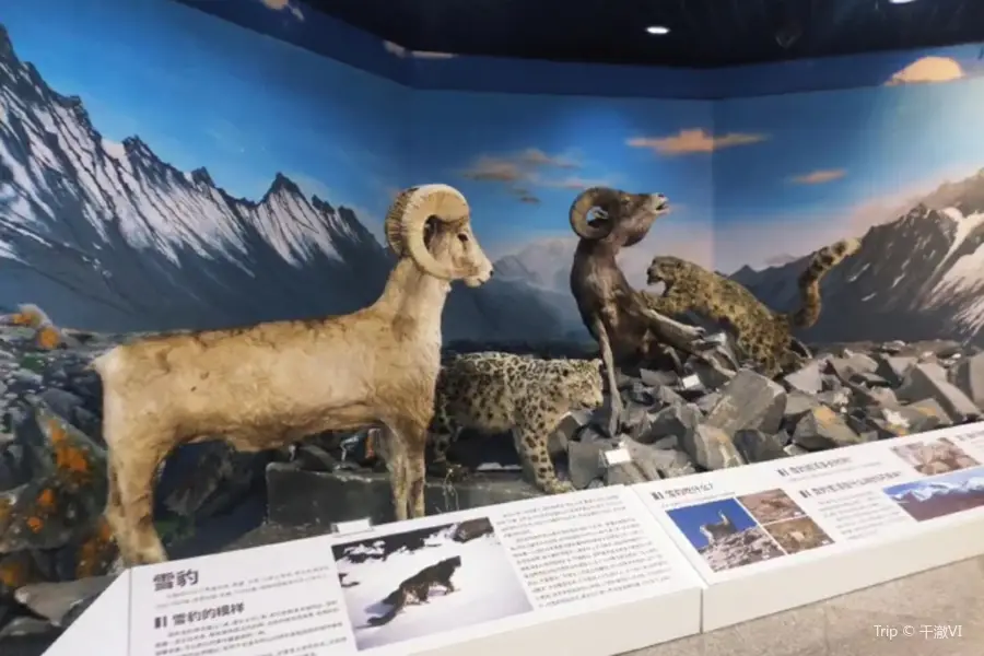
See 1 photo
xin jiang sheng tai yu di li yan jiu suo biao ben guan Highlights: Must-See Features and Attractions
Some information may have been translated by Google Translate
The museum is a multi-functional science museum with regional characteristics of inland desert and arid regions, involving two major disciplines of ecology and geography, and integrating relevant basic research, specimen collection and popular science education base. The museum was established in the 1950s on the basis of the work of the Xinjiang Comprehensive Scientific Expedition Team of the Chinese Academy of Sciences. Since the establishment of the Xinjiang Branch of the Chinese Academy of Sciences in 1956, the collection and collection of biological and soil specimens in inland arid areas of China, represented by Xinjiang, has a history of 53 years. The collection includes more than 120,000 multi-disciplinary specimens such as plants, animals, microorganisms, and soils. It is one of the comprehensive herbariums with the largest collection of specimens in Northwest my country, and has typical regional representation both internationally and domestically.
Recommendations Near xin jiang sheng tai yu di li yan jiu suo biao ben guan
xin jiang sheng tai yu di li yan jiu suo biao ben guan Reviews: Insider Insights and Visitor Experiences
Some reviews may have been translated by Google TranslateWrite a Review
/5
Outstanding ReviewsAll (29)
Latest
With Photos (2)
Positive Reviews (27)
Negative Reviews (1)
- 1
- 2
- 3
- 4
- 6
You Might Also Like
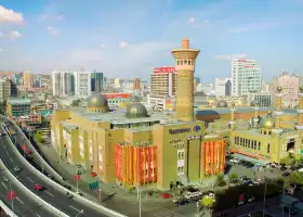
Xinjiang International Grand Bazaar
7.6
4.4/52298 Reviews
Free
Nearby Attractions
Xinjiang Uygur Autonomous Region Museum | Xinjiang International Grand Bazaar | Xinjiang Ancient Ecological Park | Liyushan Park | Hongshan Park | Urumqi Botanical Garden | Shuimogou Park | Jinmao Silk Road Park | Grand Bazaar Song and Dance Dinner | Ürümqi Water Park | 胡楊林 | Hongguang Mountain Dafo Temple | 烏魯木齊市博物館(新館) | 【烏魯木齊】譚詠麟經典傳奇巡迴演唱會 | 【烏魯木齊】任賢齊《齊跡·2024》演唱會 | 烏魯木齊文化中心 | 領館巷美食街 | Silk Road Show | Folk Street and Folk Custom Museum of Xinjiang Uygur | 新疆活體昆蟲博物館 | Asian Continent Geographic Center | Weisite Jiari Jiudian Hot Spring | Nanhu Lake | 烏魯木齊水上樂園歡樂世界 | Weisite Ski Field | Dabazha Pedestrian Street | People's Park of Urumqi | Urumqi Erdao Bridge Mosque | Xinjiang Uygur Geology Minerals Exhibition Hall | No.1 Nang in the World
Popular Types of Attractions in Urumqi
Nature | Lakes | Mountains | Geological Sites | Architecture & Landmarks | Featured Neighborhoods | Squares | landmark | Parks | City Parks | Botanical Gardens | Water Parks | Exhibition Centers | Museums | Science & Technology Museums | Exhibition Halls | Lifestyle | Resorts | Libraries | Karaoke | Fitness | Billiards | Stadiums | Martial Arts Courts | Historic Sites | Historical Sites | Cemeteries | Religious Sites | Churches and Cathedrals | Temples
Popular Restaurants in Urumqi
石榴红了·疆滋疆味(瑞豪店) | 丝路有约·新疆菜(万宴城店) | 楼兰秘烤(七道湾店) | LOVELY XINJIANG | 小尕子·新疆菜(明园店) | 和阗玫瑰抓饭(总店) | 巅峰食客(天易大厦店) | 恺撒烤包子 | 纳瓦新疆音乐餐厅(银都店) | 白尔开特特色肉馕 | CONRAD URUMQI · CENTRO Western Restaurant | TUMARIS HOTEL·Resraurant | Lvzhouda Restaurant | YUNSHANGTIANSHAN XINJIANG GOURMET FEAST | YAOAYAO | 胖老汉新疆特色椒麻鸡(河南东路店) | 映象天山·有故事的新疆菜(华润大厦店) | 来甫歌舞宴(腾飞大厦店) | 弯弯禾田烤包子 | 幸福的烤包子·新疆菜(铁路局店) | 弯弯禾田烤包子 | 丝路有约·烧烤·新疆菜(北京路汇嘉店) | PAN LAO HAN QING ZHEN CAN YIN XING FU LU DIAN | 新疆昆仑宾馆八楼 | 万廷餐饮 | Gardener Barbecue Cylinder Meat | 乌鲁木齐富力万达文华酒店·自助餐厅 | 相约·羊村小馆(长沙路店) | 巴特餐饮6加1音乐餐吧·新疆菜 | 宽窄巷子(明园店)
Popular Destinations
Launceston Travel | Kyoto Travel | Buenos Aires Travel | Busan Travel | Hay Travel | Seoul Travel | Walhalla Travel | Sydney Travel | Haikou Travel | Bali Travel | Langkawi Travel | Venice Travel | Japan Travel | Millicent Travel | Munnar Travel | Inverloch Travel | Los Angeles Travel | East Nusa Tenggara Travel | Lipu Travel | Appleton Travel | Worthen with Shelve Travel | East Hampshire District Travel | Risaralda Travel | Ripon Travel | Alpine Travel | Yiyang Travel | Spencer County Travel | North Governorate Travel | East Dorset Travel | Agawa District Travel
Recommended Attractions at Popular Destinations
Bangkok attraction near me | Manila attraction near me | Tokyo attraction near me | Hong Kong attraction near me | Seoul attraction near me | Taipei attraction near me | Los Angeles attraction near me | New York attraction near me | Shanghai attraction near me | Kuala Lumpur attraction near me | Shenzhen attraction near me | Osaka attraction near me | London attraction near me | Singapore attraction near me | Guangzhou attraction near me | San Francisco attraction near me | Beijing attraction near me | Macau attraction near me | Bali attraction near me | Paris attraction near me | Jakarta attraction near me | Ho Chi Minh City attraction near me | Orlando attraction near me | Phuket attraction near me | Chicago attraction near me | Toronto attraction near me | Cebu attraction near me | Istanbul attraction near me | Seattle attraction near me | Dallas attraction near me
Popular Ranked Lists
Popular Luxury Hotels Near Saint-Paul-De-Vence | Top 9 Local Restaurants in Malé | Popular Premium Hotels in Ginoza | Top 17 Local Restaurants in San Francisco | Top 22 Local Restaurants in Macau | Top 20 Local Restaurants in New York | Top 6 Premium Hotels in Gaziantep Province | Popular Family-friendly Attractions Near Jiang County | Popular Family-friendly Attractions Near Ganzhou | Popular Family-friendly Attractions Near Longshan | Popular Premium Hotels in Lublin | Popular Luxury Hotels Near Kosaka | Popular Luxury Hotels Near Mazara Del Vallo | Popular Family-friendly Attractions Near Rongcheng | Popular Premium Hotels in Middleburg | Popular Luxury Hotels Near Thane | Popular Premium Hotels Near Miraflores | Popular Luxury Hotels Near Cisternino | Top 20 Local Restaurants in Zhuhai | Popular Family-friendly Attractions Near Dongshan | Top 16 Local Restaurants in Edinburgh | Popular Family-friendly Attractions Near Xiaogan | Popular Family-friendly Attractions Near Sihong | Top 20 Local Restaurants in Madrid | Top 20 Local Restaurants in Ningbo | Popular Luxury Hotels Near Mavikent Mahallesi | Popular Family-friendly Attractions Near Hanyuan | Top 19 Local Restaurants in Munich | Top 4 Bars in Phi Phi Islands
Popular Trip Moments
12-Day Essence Tour of Northern Xinjiang | Xinjiang [Northern Xinjiang Ten-Day Tour] Recommended Route. | Xinjiang Northern Xinjiang 10-Day Grand Tour. | Coco-tohai Ertix River Hiking: Intimate Contact with Nature | Urumqi's summer cooling recommendation, the Grand Bazaar pedestrian street is a great place | 9 Days to Explore Northern Xinjiang! | This is the most futuristic building in Urumqi | Xinjiang Tourism, a place not to be missed is Dabancheng Ancient Town | Although the truth is harsh, this is the reality of tourism in Xinjiang | People's Park, you're really having a blast | Xinjiang | Urumqi | Off-the-beaten-path Secret – Dabancheng Salt Lake | The Urumqi Confucian Temple - A Treasure Temple of Both Literary and Martial Virtues | Urumqi Off-the-Beaten-Path Photo Spot | Tianshan Grand Canyon | Xinjiang Southern Region Tourism | 8-Day Pure Play Travel Guide | 27-Day Grand Loop Tour of North and South Xinjiang | Travel Attraction Recommendations | 【Nanshan Park in Urumqi, a Dreamy Oasis in the Dusty World】 | Urumqi's free parent-child paradise, a camping hotspot on weekends | Want to witness the largest Ferghana horse (sweat-blood treasure horse) base in China with your own eyes? Visit the Urumqi Wild Horse Ancient Ecology Park | Encounter Xinjiang's 'Mini Maldives'—A Day Trip to the Salt Lake | The fairyland lost in the mortal world - Tianshan Tianchi | At the beginning of May, the Xinjiang Museum, with its mummy figurines' expression packs and Hetian jade, can rival tourist attractions | Urumqi Recreation Spot—Haxiong Valley | Xinjiang Natural Ski Resort, Dare to Come if You Have the Guts. | Niya Museum in Minfeng County - Brocade Arm Protector | Urumqi's newly popular check-in spot, "Six Pavilions One Heart" | When you come to Xinjiang, you must see the "number one great Buddha golden statue in the Western Regions"! | 27-Day Tour around Northern and Southern Xinjiang | Yining City - Turpan - Tekes - Urumqi - Trip to Ili | An autonomous region in the northwest of China
More Things To Do in Urumqi
eSender - Mainland China eSIM daily package/traffic package, days optional. No need to get the card QR code | 2-Day Private Tour to Turpan from Urumqi: Karez System, JIaohe Ruins and More | Private Car Transfer Urumqi Airport/Urumqi hotel | Urumqi Private Transfer in English Service. Urumqi Airport to Hotel | Urumqi Private City Tour with English Speaking Driver Service | The Best of Urumqi Walking Tour | Romantic Tour in Urumqi | Urumqi Diwobao Airport Chauffeur Service, Urumqi Airport Transfer, Pickup | Urumqi Diwobao Airport Chauffeur Service, Urumqi Airport Transfer, Pickup | 6-Day Silk Road Tour from Urumqi to Dunhuang Private Tour: Urumqi, Tianshan Tianchi Lake, Turpan Bazaar, Turpan Bazaar | 4-Day Kuqa and Kashgar from Urumqi Private Tour: Kuqa Grand Bazar, Tianshan Mysterious Grand Canyon, Kuche Temple, Kuche Royal Palace | 1-Day Turpan from Urumqi Private Tour: Bezeklik Thousand Buddha Caves, Ancient City of Gaochang (Kharakhoja) | 1-Day Flexible Private Turpan Day Tour from Urumqi with Lunch Private Tour: Bezeklik Thousand Buddha Caves, Emin Minaret (Su Gong Ta), Flaming Mountains (Huoyan Shan | 1-Day Heaven Lake Private Tour: Tianshan Tianchi Lake | 2-Day Turpan from Urumqi including Jiaohe and Gaochang Ruins Private Tour: Silkroadtrips, Karez System, Toyuk Uyghur Old Village | Urumqi Private Day Tour to Xinjiang Regional Museum and Erdaoqiao Market | Xinjiang Urumqi Diwopu International Airport, Urumqi Pick-up Service | Full-Day Private Guided Tour to Heavenly Lake of Tianshan | 7-Day Urumqi,Turpan,Kashgar Private Tour include Kumtag Desert, Ancient city of Jiaohe | 5-Day Urumqi to Kanas Private Tour: Kanas Lake Natural Reserve | Private Day Tour to Kashgar from Urumqi by Round-way Flight | Private 2-Day Trip to Turpan from Urumqi including Jiaohe and Gaochang Ruins | 3 Days Urumqi Heavenly Lake and Turpan Tour | Private Full-Day Tour to Dushanzi Grand Canyon from Urumqi | 4-Day Urumqi Private Tour to Southern Pasture, West Baiyanggou Scenic Area | Private 2D Tour to Kizil Caves, Subash Ruin etc. from Urumqi by Round-way Flight | All Inclusive Private Urumqi Day Tour including Erdaoqiao Market | Private Day Tour to Kizil Caves and Tianshan Canyon from Urumqi by Air | Private Afernoon Tour to Erdaoqiao Bazaar and Show with Dinner in Urumqi | 7-Day Private Silk Road Trip Urumqi to Dunhuang and Zhangye
Payment Methods
Our Partners
Copyright © 2024 Trip.com Travel Singapore Pte. Ltd. All rights reserved
Site Operator: Trip.com Travel Singapore Pte. Ltd.
Site Operator: Trip.com Travel Singapore Pte. Ltd.
In the past, the Junggar Basin was defined as 380,000 square kilometers, and now some areas such as the east of Beita Mountain are not part of the Junggar Basin, with the latest data being 180,000 square kilometers. The Junggar Basin is low in the east and west, and it leans slightly northward, with an average altitude of about 500 meters, the lowest point is Lake Aibi, and the lake is 189 meters above sea level.
[View] 👍👍👍👍👍👍👍👍 [Fun] [Fun] 👍👍👍👍👍👍👍👍👍 [Cost-effective] 👍👍👍👍👍
Very, very worth going, eye-opening long knowledge, can learn a lot, adults and children are interested, grand recommendation
The location of Xinjiang branch of the Chinese Academy of Sciences! The location of the Xinjiang Earthquake Bureau!
[View] Good [Fun] Funny [Cost-effective] OK