OverviewNearbyReviewsWin PrizesRecommended
Share to
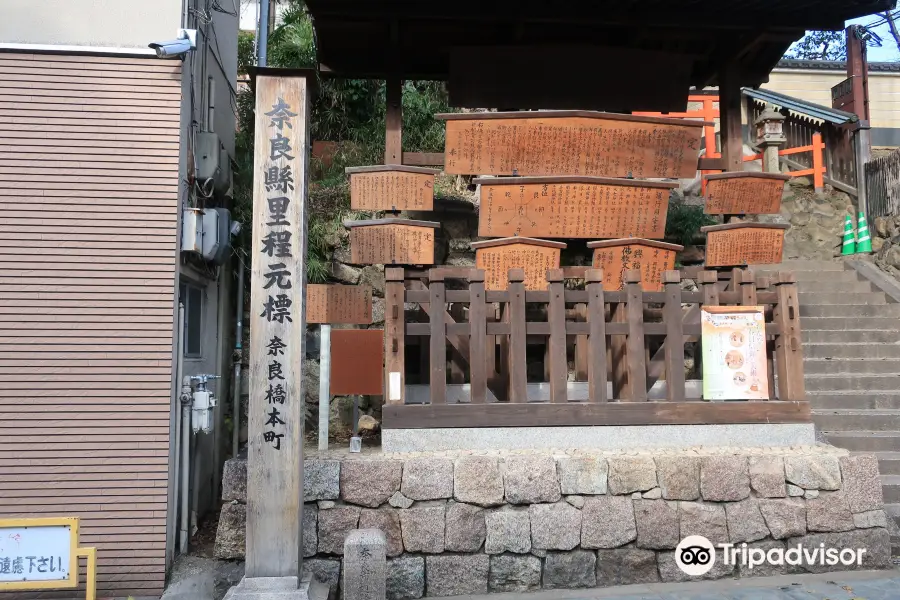
Nara Prefecture Kilometer Zero
1.0
 based on 15 reviews
Address:
Hashimotocho, Nara 630-8217 Nara PrefectureMap
What travelers say:
See all 3 photos
Recommendations Near Nara Prefecture Kilometer Zero
Nara Prefecture Kilometer Zero Reviews: Insider Insights and Visitor Experiences
Write a Review
 Trip.com
 (15 Reviews)TripAdvisor15 Reviews
You Might Also Like
Umeda Sky Building
7.3
4.6/5798 Reviews
Save AU$ 0.89
From AU$ 13.80
Osaka Castle Main Tower (Osaka Castle Museum)
7.2
4.6/51429 Reviews
From AU$ 5.64
Tsutenkaku
7.1
4.5/5592 Reviews
Save AU$ 0.49
From AU$ 9.31
LEGOLAND Discovery Center Osaka
7.0
4.4/5315 Reviews
Nearby Attractions
Nara Park | Tōdai-ji | Kasuga Taisha | Osaka Castle Park | Toshodaiji | Mount Wakakusa | Kofuku-ji | Dotombori | Nara National Museum | Naramachi | Shinsaibashisuji | Umeda Sky Building | Todai-ji Nigatsudo (February Hall) | Osaka Castle Main Tower (Osaka Castle Museum) | Osaka Castle | Tsutenkaku | Shinsekai | Yakushiji Temple | Isui-en Garden and Neiraku Museum of Art | Abeno Harukas 300 | Kuromon Ichiba Market | Umeda | Hep Five Ferris wheel | Namba | Kuchu Teien Observatory | Kids Plaza Osaka | Mt. Kasuga Primeval Forest | Heijō Palace Site Historical Park | Higashimuki Shopping Street | America-mura
Popular Types of Attractions in Nara
Parks | City Parks | Botanical Gardens | Amusement Parks | Religious Sites | Other Places of Worship | Temples | Churches and Cathedrals | Exhibition Centers | Museums | Art Museums | Art Galleries | Architecture & Landmarks | Monuments | landmark | Observation Decks | Historic Sites | Historical Sites | Castles | Cemeteries | Lifestyle | Hot Springs | Entertainment Centers | Libraries | Popular Spots | Nature | Lakes | Mountains | Attractions | Outdoor Sports
Popular Restaurants in Nara
La Terrace | Main Dining Room ”MIKASA” | Kikusuiro | Wa Yamamura | Bikkuri Udon | Tsukihitei Kintetsu-Nara-ekimae | Kamameshi Shizuka Kouen-ten | NakanishiYosaburo | Mizuya Chaya | Tsuruyoshi | Awa Naramachi | La Terass Irisee | ニクバルダカラ 大和西大寺店 | Tsukumo | Kakinohasushi Hompo Tanaka | Kichiza Den’emon | Mellow Café | Yatagarasu | Menya Noroma | Onjaku | Tou No Cha-Ya | China Dining Hiten | TRATTORIA piano | Kanakana | Kaiseki Cuisine Kakomura | KURA | Gateau des Bois | Genkishin (Nara) | Kameya | Grilled Eel Edogawa in Naramachi
Popular Destinations
Kortrijk Travel | Hechi Travel | Taoyuan Travel | Stanthorpe Travel | Japan Travel | Split Travel | Auckland Region Travel | Mykonos Travel | Kuala Lumpur Travel | Vietnam Travel | Shangrao Travel | Marrakech Travel | San Francisco Travel | Cervantes Travel | Maldives Travel | Lanzhou Travel | Morocco Travel | Doha Travel | Islamabad Travel | Stavropol Travel | Maidstone Travel | New London Travel | Estherville Travel | Morondava Travel | Broadland Travel | Alagoas Travel | Can Tho Travel | Lewisboro Travel | Wailea Travel
Recommended Attractions at Popular Destinations
Bangkok attraction near me | Tokyo attraction near me | Manila attraction near me | Hong Kong attraction near me | Taipei attraction near me | Seoul attraction near me | Los Angeles attraction near me | New York attraction near me | Shanghai attraction near me | Kuala Lumpur attraction near me | Shenzhen attraction near me | Osaka attraction near me | Singapore attraction near me | London attraction near me | Guangzhou attraction near me | San Francisco attraction near me | Beijing attraction near me | Macau attraction near me | Bali attraction near me | Paris attraction near me | Ho Chi Minh City attraction near me | Orlando attraction near me | Jakarta attraction near me | Phuket attraction near me | Chicago attraction near me | Toronto attraction near me | Fukuoka attraction near me | Istanbul attraction near me | Dallas attraction near me | Cebu attraction near me
Popular Trip Moments
Kasuga Taisha 🇯🇵 | 🇯🇵 Nara deer park | Feeding crackers to well-mannered deer 🙇♂️ | Deer park 🇯🇵 | Nara Park | Kansai Travelogue: Nara Edition | Nara Deer park Covered in pink 🌸🇯🇵 | It is said that 99% of visitors to Nara miss the sunset at Nigatsu-dō | Sakura in Osaka - Nara | 🌸 Cherry Blossom in Japan 🌸 | Global Autumn Pursuit | Nara Park during the Maple Leaf Season | Kyoto, Japan | Went to a city for a group of deer | Nara Deer Park in Osaka🦌 | In Nara Park, Japan, you can interact with deer up close | Kansai 7-Day Private Tour - Experience the History and Charm of Japan! | A Blossoming Haven of Serenity | Nara Park, Japan. | 👨🏻🍳 Man with Haik-Haik at Work! | My Moments have been bombarded with questions, and this time it's for real—I'm abroad in Nara | Nara: A Luxury Hotel with Open-Air Onsen, Embracing the History and Culture of the Ancient Capital | 🦌 Oh My Nara Deer! | Warmth Meal in Cold Weather | 🏢 Lush in Compact Hotel | Todaiji Temple | Classical Japanese Garden To-in teien Garden | Isuien Garden and Neiraku Museum | Mt. Kasuga Primeval Forest | 5-Day 4-Night Special Forces Travel in Kansai, Japan: 'Nara, Kyoto Edition' | Shirataka Ookami | A wonderful peaceful park in nara | Nara during Cherry Blossom Season
More Things To Do in Nara
JR Haruka Express Train Ticket: Kansai Airport to Tennoji/Shin-Osaka/Osaka/Kyoto/Nara/Kobe (Instant Confirmation) | Japan eSIM Day Pass/Data Package (QR Code) | JR Kansai Wide-Area 5-Day (immediate e-voucher issue) | eSIM-Japan Daily 500MB/1GB/2GB/3GB, Total 5GB/10GB/20GB/50GB, Unlimited Traffic All-you-can-eat | JAPAN RAIL MINI PASS Kansai Area (3 Days | JR Pass) | One-day trip to Kyoto City + Nara + Osaka, Japan [13 Standard Price small group | Kimono experience | Chinese-speaking driver | Nara cute deer | Arashiyama Train Tickets] | Japan eSIM 4G high-speed network QR code | Japanese WiFi rental (high speed throughout the journey without slowing down) (pick up and return at Hong Kong Airport) | Japanese esim|softbank local native line daily 500MB/1GB/2GB/3GB | KANSAI THRU PASS 2 Days/3 Days | Asia・Australia eSIM|AIS SIM2Fly 8 days 6GB High-speed Unlimited 5G/4G Data | [Japan] DOCOMO eSIM Data Package QR code | Kyoto Sakakujing Kimono Experience | Haruka Airport Express - Kansai Airport to/from Osaka/Shin-Osaka/Kyoto/Nara/Kobe/Tennoji | One-day trip to Kyoto + Nara, Japan (Kiyomizu Temple + Fushimi Inari Taisha Shrine + meet cute deer in Nara Park) Departing from Osaka/Kyoto | Japan Kiyomizu Temple + Fushimi Inari Shrine + Nara Park + Shinsaibashi + Dotonbori Day Tour [Adjustable itinerary/2 people per trip] | One-day tour of Arashiyama, Deer Park and Nara Park in Japan [Feed the deer] English Guide+ Chartered Vehicle itinerary adjustable] | KYOTO-NARA with Private Car & Driver (Max 7 Pax) | Japan Osaka City/Kyoto/Nara/Kobe Chartered One-Day Tour Departing from Osaka City Door-to-door Pick-up | JR PASS Sanyo & Sanin 7-day/Sanin & Okayama 4-day JR PASS rail pass [electronic ticket] | Enjoy Arashiyama, Kinkakuji, Todai-ji and Nara Park! (Osaka departure) | Japan Meguro River+Hakone+Izu Sea Viewing Train+Kinosaki Coast+Kawazu Sakura+Kyoto Arashiyama+Nara Park+Universal Studios Japan Six-Day Charter Tou | Japan Osaka + Kyoto + Nara + Nara Park + Kiyomizudera one-day tour [23 Osaka, Yasaka Shrine, Fushimi Inari Taisha, Todaiji Temple, 4 Standard Price, departure every day] | Japan JR Kansai Area Rail Pass | Japan Meguro River+Hakone+Izu Sea View Train+Kinosaki Coast+Kawazu Sakura+Chibi Maruko-chan Paradise+Kyoto Arashiyama+Nara Park Five-Day Charter Tour | Nara private tour (Shore excursion available from Osaka or Kobe port) | Relax in Nara: Deer Park, Todai-ji Temple and Merchants' Town | Explore the best spots of Arashiyama / Nara in a One Day Private Tour from Kyoto | Japan Kasuga Taisha Shrine + Todaiji Temple + Yoshinoyama one-day tour [Chinese-speaking car transfer + flexible itinerary + Osaka round trip -] | 7-Day Best Japan Tour
Payment Methods
Our Partners
Copyright © 2024 Trip.com Travel Singapore Pte. Ltd. All rights reserved
Site Operator: Trip.com Travel Singapore Pte. Ltd.
Site Operator: Trip.com Travel Singapore Pte. Ltd.
Xingfu Temple is near く
It is located along Sanjo-dori near Kofukuji Temple. It is a former sign that was installed as the starting point of the prefecture's highway during the Meiji era. In the case of Nara, it was the starting point for Kyoto, Osaka, and Ise. I don't have the image of Nara as a highway, and I feel like it's here.
Gaochun Field の Place
After worshiping Nanendo, I stood in the place immediately after coming down to Sarusawa Pond. It was more conspicuous to reproduce the Kosatsuba, and the details were understood on the explanation board of both. Unfortunately, there were few tourists themselves, so the locals didn't seem to look at them.
Fuyuan した Gaoyuchang にある Mileage Yuanbiao
A little in front of Sarusawa Pond, a lot of tags and pillars made of wood along Sanjo-dori, southwest of Kofukuji Temple. The thick wooden pillars are called "Nara Prefecture Midland Motomark", and the Midland Motomark is based on each 1 in the prefecture as a starting point for measuring distance. Many other bills are restored from "Gokosatsuba". Kosatsuba was posted in a place where the shogunate and the feudal lord decided the law and the codes on the wooden board bills and put them high so that they could be seen. Behind it ...
Road marker
A bulletin board of a signboard tree? There were many things like that. How many steps to Kyoto, who will walk? There were many signs that walked like that. It is located near the entrance of the shopping street of Sanjo Dori street.
Before Gaochun Field の
A wooden square pillar was built in front of the Kosatsuba along Sanjo-dori, and it was written as "Nara Prefecture Midland Motoshi Nara Hashimotocho". I thought it was a little halfway place to be the center of surveying.