OverviewBookNearbyReviewsWin PrizesRecommended
Share to
Qiancengfeng National Geology Park
千層峯2.7
27 Reviews
Closed Today Open tomorrow at 09:00-18:00(Tickets available until 17:00)
Recommended sightseeing time:1-2 hours
Address:
Fengkai, Zhaoqing, Guangdong, ChinaMap
Phone0758-6380369, 0758-6318321
What travelers say:
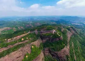
To visit the Qianfen Peak, take the scenic shuttle Golf car to the observation deck. From here, you can see the peaks close, layer by layer, it is really like a thousand-layer cake. There is a river next to the peak, from the top to the bottom, the water is panting. Afterwards, the river was relatively calm, but with sand and mud, the river was turbid, and looked up at the thousand-story peaks, the scenery was wrong. There are many local shops along the way, you can watch the scenery and buy it.
MoreRecommendations Near Qiancengfeng National Geology Park
Qiancengfeng National Geology Park Reviews: Insider Insights and Visitor Experiences
Some reviews may have been translated by Google TranslateWrite a Review
/5
Excellent ReviewsAll (27)
Latest
With Photos (13)
Verified Booking (1)
Positive Reviews (19)
Negative Reviews (2)
- 1
- 2
- 3
- 4
- 6
You Might Also Like
Shibiao Mountain
5.1
4.1/5172 Reviews
Save AU$ 2.12
From AU$ 8.50

China Skydivers
3.6
4.6/563 Reviews
From AU$ 462.76
Gupo Mountain
6.4
4.6/54022 Reviews
Save AU$ 1.70
From AU$ 12.32
Jade Forest Scenic Area
5.9
4.4/51022 Reviews
Save AU$ 6.16
From AU$ 6.05
Nearby Attractions
Qilou Buildings | Hejiang Bidao Gallery Scenic Area | Qidi Hongxing Yuzhou Snow Cube Ice and Snow World | White Cloud Mountain | Wuzhou Museum | Dragon Mother Temple | Dabanshi | Wuzhou Zoo | Self-driving Travel Camp | Meiguihu Park | Li Jishen's Former Residence | 西江明珠塔 | 明朝兩廣總督府 | Yangchi Ancient Village | Dawang Mountain Forest Park | 梧州市蒼海湖 | United Kingdom Consular Department Site | Hebin Park | Xijiang Bridge | Taihe Garden | Sien Temple | Guangxin Beidi Temple | Zhongshan Park | Canghai Park | Wuzhou Military Sports Cultural Park | Zhongshan Park of Wuzhou | Shizheng Square | Wuzhou Guilinggao Gongye Tourism | Baihe Taoist temple | Weixinli Dwellings
Popular Types of Attractions in Fengkai
Parks | City Parks | Children's Play Areas | Water Parks | Architecture & Landmarks | Squares | Featured Neighborhoods | Historical Architectures | Exhibition Centers | Fine Art Galleries | Museums | Memorial Halls | Lifestyle | Libraries | Campgrounds | Resorts | Religious Sites | Memorial Temples | Temples | Churches and Cathedrals | Nature | Mountains | Forests | Lakes | Fitness | Badminton Courts | Stadiums | Basketball Courts | Historic Sites | Historical Sites
Popular Restaurants in Fengkai
雷氏面家(江口店) | 广远杏花鸡山庄 | 姚记大排档 | 如苑酒楼 | 富华小食轩(封开店) | 华莱士·全鸡汉堡(南丰店) | 阿贵河鲜(佰隆山河店) | 冬瓜鸡 | Qiangzhongshoudunpinguan (jianshe'erlu) | 老谢大排档(封开店) | 聚裕食店 | 博爱炖品(红卫路分店) | 河口人家饭店 | 封开风水间民宿·品味斋 | 安仔农庄 | 签到 | 昆昆凉茶 | 麦当劳(汇景湾店) | 桂香苑(大塘店) | 囍盈来 | Hualaishi (jiangkou) | 杏花农庄 | GONG SHU LIN | 桂香苑(虹桥店) | 龙山餐厅 | 相约烘焙 | 如意馆私房菜(大塘店) | 意卡滋餐厅 | LING NA DI YI GUO ZUI NIU DE NIU ZA | 心悦甜品屋
Popular Destinations
Eaglehawk Neck Travel | South Korea Travel | Burleigh Heads Travel | Hamilton Island Travel | Kuala Lumpur Travel | Vietnam Travel | Asahikawa Travel | Caulfield Travel | Stralsund Travel | Gladstone Travel | Springwood Travel | Okinawa Travel | Singapore Travel | Vancouver Travel | Toronto Travel | Gangneung-si Travel | Nagaokakyo Travel | Aurora Travel | Nepal Travel | Nice Travel | Easter Island Travel | Yizhou District Travel | Grodno Region Travel | Greenland Travel | Ballymena Travel | Sosua Travel | Footscray Travel | Edzell Travel | Zigui Travel | Nordwestmecklenburg Travel
Recommended Attractions at Popular Destinations
Bangkok attraction near me | Tokyo attraction near me | Manila attraction near me | Hong Kong attraction near me | Taipei attraction near me | Seoul attraction near me | Los Angeles attraction near me | New York attraction near me | Shanghai attraction near me | Kuala Lumpur attraction near me | Shenzhen attraction near me | Osaka attraction near me | Singapore attraction near me | Guangzhou attraction near me | London attraction near me | San Francisco attraction near me | Beijing attraction near me | Macau attraction near me | Bali attraction near me | Paris attraction near me | Ho Chi Minh City attraction near me | Orlando attraction near me | Jakarta attraction near me | Phuket attraction near me | Chicago attraction near me | Toronto attraction near me | Istanbul attraction near me | Cebu attraction near me | Dallas attraction near me | Seattle attraction near me
Popular Travel Types
More Things To Do in Fengkai
China eSIM Day Pass/data Package days selected without cards QR code | China·Hong Kong·Macau eSIM|Unlimited 4G High-speed Data | China Mainland eSIM|China Mobile Unlimited 4G High Speed Data | China, Hong Kong, and Macau eSIM|Total 5GB/10GB/15GB/20GB High-speed 4G LTE Unlimited high-speed data | Mainland China eSIM |China Mobile 4G high-speed unlimited data eSIM | Asia・Australia eSIM|AIS SIM2Fly 8 days 6GB High-speed Unlimited 5G/4G Data | [China Mainland] eSIM | SIM to China | 8GB 8days 4G high speed | Mainland China + Hong Kong + Macau eSIM 4G Data Daily Plan QR Code | Trip.SIM Japan, South Korea, Macau, Taiwan and many places in Asia + Australia and New Zealand 4G travel data roaming phone network card 4 days/7 days | eSender - Mainland China eSIM daily package/traffic package, days optional. No need to get the card QR code | [China, Hong Kong and Macau] 4G network | Unlimited traffic | Self-pickup at the airport | WiFi rental, high-speed traffic, shared by multiple people, ready to use at startup, 12H standby, 24H customer service | China/Hong Kong/Macau eSIM 4G high-speed network QR code | China, Hong Kong, Macau 4G SIM Card (HK, Macau, Taiwan, China Delivery Only) | Global multi-region A series eSIM|High-speed data, travel and business Internet access, optional unlimited data, optional days, QR code | Mainland China + Hong Kong + Macau eSIM Data Plan QR Code | China, Macau eSIM - Data plan by Gohub (QR Code) | Asia 9 Destinations eSIM 4G Data Plan QR Code | eSender- Brunei/Indonesia/Singapore/Japan and many other countries and regions eSIM daily package/data package (QR code) | Guilin Day Trip to Huangyao Old Town in Hezhou | China, Hong Kong, Macau eSim 1/3/7/15/30 days (sent via email) by Xplori | AIS Global esim data package (QR code) | 2-Day Private Tour from Guilin/Yangshuo to Guangzhou With the Driver | AIS SIM2Fly Global eSIM|15 days 6GB high-speed 4G/5G Unlimited Data | AIS Asia esim data package (QR code) | [FLASH SALE] China, Hong Kong, Macau eSIM - Data plan by Gohub (QR Code) | 【5G SIM Card】China・National 5G Universal SIM Card |Total 10GB/15GB/30GB/45GB High-speed 5G Unlimited Data Service (Pick up at Shanghai Pudong T2) | One-day tour to Hezhou, China + Huangyao Ancient Town + Zhongshan Shili Gallery [Specialty Camellia oleifera in the hometown of longevity | Mountain pig | Orchard chicken | Fruit picking on the mountain, quality chartered car] | [Hong Kong, Mainland China] 4G Internet Card | China Unicom/Hutchison | Unlimited data SIM card | Optional days | Insert the card and use | Self-pickup at Hong Kong Airport | Private Day Tour Huangyao Old Town in Hezhou from Guangzhou by Round-way Train | Global eSim for 140+ countries (sent via email) by Xplori
Payment Methods
Our Partners
Copyright © 2024 Trip.com Travel Singapore Pte. Ltd. All rights reserved
Site Operator: Trip.com Travel Singapore Pte. Ltd.
Site Operator: Trip.com Travel Singapore Pte. Ltd.
To visit the Qianfen Peak, take the scenic shuttle Golf car to the observation deck. From here, you can see the peaks close, layer by layer, it is really like a thousand-layer cake. There is a river next to the peak, from the top to the bottom, the water is panting. Afterwards, the river was relatively calm, but with sand and mud, the river was turbid, and looked up at the thousand-story peaks, the scenery was wrong. There are many local shops along the way, you can watch the scenery and buy it.
 catalog  5,000-story peaks are located on the banks of the Huanggang River, 8 kilometers southeast of Yuqi Town, Fengkai County, Guangdong Province. It is composed of heavy overlapping colorful sand shales and local calcium shales. It belongs to the sandstone peak forest landform, formed in the mud plate period 380 million years ago. It is also the peak caused by the oldest mountain orogeny in China. It is one of the standard places of the two Jiali East orogeny in Guangdong. The peaks here stand tall, lush, and the main peak is 233 meters high. Although the mountain is not high, but set "Huangshan's wonder, Huashan's danger, Lushan's show, Emei's secluded" in one.
"Thousands of layers of peak" is located on the Huanggang River, 8 kilometers southeast of Yuqi Town, Fengkai County, Zhaoqing, Guangdong Province. It is composed of heavy overlapping, colorful sand shale and local calcium shale. It belongs to the sandstone peak forest landform, formed in the mud plate period 380 million years ago. It is worth mentioning that the Qianshifeng is still the oldest mountain orogeny in China, and the peak caused by the "Jiali East Mountain Orogeny" is one of the standard places of two Jiali East Mountain orogeny in Guangdong. So it has become a geological and geomorphological feature that records how the earth's continental plates evolved from 100 million years ago to today. The CCTV "Geographic China" column has visited and photographed many times. 💎 Fengkai Qianfenfeng 💰 Ticket + Battery Car: 50 yuan/person ⏰ Open Time: 8:30~ 17:30📍 Detailed Address: Interesting Soul on the Road of Qianfenfeng Scenic Area, Yuqi Town, Fengkai County, Guangdong Province ~
Very happy times are always so happy times!!!
Very happy times are always exciting!!!!
Very good place, human geography and natural scenery, it is really tired to travel around three places a day
Very satisfied experience, trustworthy friends! ! ! ! !