The upper source of the Lijiang River (Darong River, flowing from north to south into the sea) and the upper source of the Xiangjiang River (Ocean River, flowing from south to north and then east into the Yangtze River into the sea), just happened to be in Xing'an County, Guangxi, and the distance was only 1.5 kilometers, and the low mountain beam in the middle was not more than 30 meters high and 500 meters wide. The designer of Lingqu is to use this geographical condition, hard to chise out a waterway, lead Xiang into the undulating hills, connect the Xiangjiang River and Lijiang River to divert the north and south, communicate the Yangtze River water system and the Pearl River water system. Cross the bridge to see the scales. Lingqu is about 30 kilometers long and about 5 meters wide. It is opened to dig Lingqu. First, the Xiangjiang River is separated by the stone embankment and the size of the Tianping, which is used to build the composition of the water mouth and the size of the Tianping. In front of the mouth, two canals are opened from the north to the south. The north canal is still connected to the Xiangjiang River. Upstream of the Xiangjiang River, the water from the Haiyang River is divided into two mouths, which flows into the South Canal and the North Canal, which connects the Xiangjiang River and the Lijiang River. When the water from the Haiyang River is large, the Lingqu canal can be discharged to the ancient road of the Xiangjiang River through overflowing floods such as large and small Tianping, ensuring the safety of the canal. Lingqu chose to be in a very close distance between Xiangjiang and Lijiang River, where the water level is not much different, and the canal route is looped back to reduce the river bed ratio, calm the water trend, and facilitate boating. The design and layout of Lingqu are very scientific. It occupies a glorious position in the history of world shipping. It turned out that people can walk on the scales, but now it is not possible, only dogs can walk. Walk along the upstream of the Buddha Yin Temple, the river is very clear, and the water grass can be seen at the bottom of the water.
;
Lingqu Review
4.4 /5566 Reviews


1 / 5


4/5
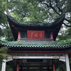
Lingqu
Posted: Feb 7, 2020
4 person liked this
Like
 5/5Outstanding
Verified Booking
Original TextLingqu is a small attraction, but it is worth seeing. It is best to ask a tour guide to explain, you can understand the historical role of Lingqu in more detail and clearly. When the cruise ship, the tour guide will also play guzheng, playing very well, and cooperate with that field. Very freehand.
Posted: Sep 30, 20230 4/5Excellent
Verified Booking
Original TextEveryone knows Dujiangyan, but I don't know that there is a spiritual channel, in fact, the two are very similar. The scenery is good and the service is very good. . . . . . . . . . . . . . . . . . . . . . . . . . . . . . . . . . . . . . . . . . . . . . .
Posted: Jun 14, 20230 5/5OutstandingOriginal Text
Lingqu, which was cut into navigational channels in 214 BC, is the oldest canal in the world. It connects the Xiangjiang River at the source of Xing'an County with the Lijiang River at the source of the Darong River. The entire canal is composed of grin, big balance, small balance, south canal, north canal, water culvert, steep gate, dam, Qindi, bridge and so on. Open-air park-style attractions, surrounded by charges, really indescribable
Posted: Nov 22, 20223 5/5OutstandingOriginal Text
Xing'an ~ Lingqu 👍👍👍 2,000 years of history, now Zhongzhong is in use, really a great builder 👍 Entering Lingqu from the gate is really very historical value. Although the Lingqu is not wide, it can be circled and traveled. It is feasible to dry on both sides. Today, Lingqu Zhong has retained the previous sluice. The water quality is very awkward, you can see the green grass under the water
Posted: Jul 30, 20220 5/5Outstanding
Verified Booking
Original TextEverything that should be returned will come back even if it wade through the mountains and rivers
Posted: Sep 11, 20230- 1
- 2
- 3
- 4
- 100
Popular Destinations
Valldemossa Travel | Phuket Travel | Yverdon-les-Bains Travel | Koh Samui Travel | Hue Travel | Kalutara Travel | Kununurra Travel | Pemberton Travel | Mount Tamborine Travel | Kanazawa Travel | Türkiye Travel | Lisbon Travel | Malta Travel | Taiwan Travel | Tehran Travel | Valletta Travel | Namibia Travel | Batemans Bay Travel | North Adams Travel | Jing County Travel | Peebles Travel | Maidstone Travel | Topeka Travel | Victor Travel | Morondava Travel | Sarasota Travel | Alagoas Travel | Naantali Travel | Lewisboro Travel
Recommended Attractions at Popular Destinations
Bangkok attraction near me | Tokyo attraction near me | Manila attraction near me | Hong Kong attraction near me | Seoul attraction near me | Taipei attraction near me | Los Angeles attraction near me | New York attraction near me | Shanghai attraction near me | Kuala Lumpur attraction near me | Shenzhen attraction near me | Osaka attraction near me | Singapore attraction near me | London attraction near me | Guangzhou attraction near me | San Francisco attraction near me | Beijing attraction near me | Macau attraction near me | Bali attraction near me | Paris attraction near me | Orlando attraction near me | Jakarta attraction near me | Ho Chi Minh City attraction near me | Chicago attraction near me | Phuket attraction near me | Toronto attraction near me | Cebu attraction near me | Dallas attraction near me | Istanbul attraction near me | Seattle attraction near me
Popular Attractions
Hong Kong Space Museum | Royal National Park | David Fleay Wildlife Park | Kalavathy Water falls | Fairy Mountain National Forest Park | Peninsula Hot Springs | Wuhou Shrine | Chengdu Research Base of Giant Panda Breeding | Sunway Lagoon Theme Park | Adelaide Arcade | Bali Aloha Ubud Swing | Nantou Ancient Town | Dujiangyan Irrigation System | Centennial Park | Kloster Engelberg - Benediktinerabtei | Borghese Gallery and Museum | SUMMIT One Vanderbilt | Tianyi Pavilion Museum | La Mauresque | Chua Thanh Cao | Safa Mosque | Fitness trail | Memorial Park at The End of World War ll | MadeByYou | Banchangyuwonji | Temple | Castle Park | Masjid Nurul Huda | Tsim Sha Tsui | Hong Kong Disneyland
Popular Travelogues
Bangkok Travelogue | Tokyo Travelogue | Hong Kong Travelogue | Seoul Travelogue | Los Angeles Travelogue | New York Travelogue | Shanghai Travelogue | Kuala Lumpur Travelogue | Shenzhen Travelogue | Osaka Travelogue | Singapore Travelogue | London Travelogue | Beijing Travelogue | Macau Travelogue | Bali Travelogue | Paris Travelogue | Phuket Travelogue | Toronto Travelogue
Popular Ranked Lists
Top 5 Premium Hotels in Chengde | Popular Premium Hotels in Utorda | Top 20 Fine Dining in Abu Dhabi | Popular Family-friendly Attractions Near Jingyang | Top 12 Premium Hotels in Bourgogne-Franche-Comte | Popular Premium Hotels in Jiaozuo | Top 15 Local Restaurants in Doha | Top 10 Local Restaurants in Boracay Island | Popular Premium Hotels in Bang Sai | Popular Luxury Hotels Near Arkadii | Top 5 Premium Hotels in Huangshan Scenic Area | Top 15 Fine Dining in Venice | Popular Luxury Hotels Near Avsallar | Top 10 Award winning restaurants in Sabah | Popular Premium Hotels in Songyang | Popular Fine Dining in Los Angeles | Top 9 Fine Dining in Budapest | Popular Premium Hotels in Atlixco | Popular Fine Dining in New York | Popular Nightlife Districts in Dublin | Popular Nightlife Districts in Taipei | Popular Nightlife Districts in Jinghong | Popular Nightlife Districts in Changsha | Top 4 Nightlife Districts in Osaka | Popular Nightlife Districts in Pattaya | Popular Nightlife Districts in Phuket | Popular Nightlife Districts in Beijing | Popular Nightlife Districts in Kaohsiung | Popular Nightlife Districts in Shanghai
Payment Methods
Our Partners
Copyright © 2024 Trip.com Travel Singapore Pte. Ltd. All rights reserved
Site Operator: Trip.com Travel Singapore Pte. Ltd.
Site Operator: Trip.com Travel Singapore Pte. Ltd.