OverviewBookNearbyReviewsWin PrizesRecommended
Share to
Xar Moron Grand Canyon
西拉沐淪大峽谷園區3.6
29 Reviews
Open Opens at 8:00-17:30
Recommended sightseeing time:1-2 hours
Address:
About 20 kilometers south of Jingpeng Town, Keshiketeng Banner, Chifeng CityMap
What travelers say:
The Xila Mulun Grand Canyon, geology is called the Xila Mulun deep fault, which is located on the southern edge of the Daxingan Mountains, and extends near east-west along the Xila Mulun River, which is 340 kilometers long and 50 kilometers wide. It is one of the most important deep faults in the region.
More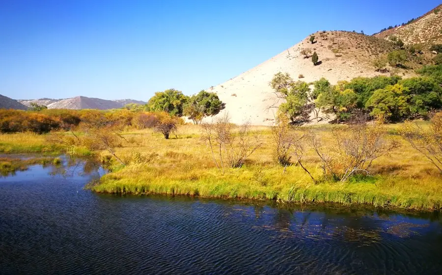
See 1 photo
Xar Moron Grand Canyon Highlights: Must-See Features and Attractions
Some information may have been translated by Google Translate
The Xilamulun Grand Canyon is located on the southern edge of the Greater Khingan Mountains and extends in a near east-west direction along the Xilamulun River. In the scenic area, the mountains are high and the valleys are deep, and the riverbeds jump and leap over the streams, forming Daodao waterfalls. On both sides of the canyon, the bridge is overgrown with shrubs, and the water flow at the source is cut off abruptly. The valley is a long basin. The basin runs from west to east. In some parts of the upper reaches of the Xilamulun River, the two mountains face each other, as steep as a knife, and its height needs to be looked up. When the two banks are close to each other, the cliffs and trees overlap gradually without gaps. When you walk into the cliff corner, the peaks and turns turn around, and there is another cave, known as the "Little Three Gorges". The Xilamulun River converges with the Shali River and the Saling River, and flows straight down, passing through the nine bends and eighteen bays, and entering a cliff canyon two kilometers long. "Longkou". A water park has been built here, where you can go fishing, rafting, and speedboats.
Recommendations Near Xar Moron Grand Canyon
Xar Moron Grand Canyon Reviews: Insider Insights and Visitor Experiences
Some reviews may have been translated by Google TranslateWrite a Review
/5
Excellent ReviewsAll (29)
Latest
With Photos (18)
Positive Reviews (16)
- 1
- 2
- 3
- 4
- 6
You Might Also Like

Gubei Water Town
7.7
4.7/513977 Reviews
Save AU$ 4.25
From AU$ 29.79

Simatai Great Wall
6.0
4.7/51117 Reviews
From AU$ 8.51
Nearby Attractions
Rehuitang Town | Jingpeng Town | Keqi Qingshan National Geological Park | China Hexigten Global Geopark Museum | Daqingshan Quaternary Period Glacial Relic Park | Hexigten Global Geopark Qingshan Area | Hunshandake Desert | 克什克騰旗龍口漂流 | Jingpeng Square | 草原天牧温泉小鎮 | Xilamulun Shibawan Drifting | Lierenshu Hot Spring Resort | Moulin Wonder | Longkou Lvyou Dujia Center | 二道橫河子 | 鐵馬影視基地 | 熱水塘温泉園區 | 經棚清真寺 | Keqi Feiyue Taiqiu Club | 東方跆拳道館 | 民族產品彙展中心 | 金木石藝術館 | 應昌街道賽罕社區居民活動中心 | 青山巖臼 | 少兒圖書館 | 克什克騰旗圖書館 | Xiaoke Touhe | Geleihe | Qingning Temple | Wuyi Guan Canal
Popular Types of Attractions in Keshenketengqi
Nature | Grasslands | Mountains | Forests | Architecture & Landmarks | Squares | Historical Architectures | Featured Neighborhoods | Lifestyle | Resorts | Karaoke | Libraries | Traditional/Cultural Experiences | Villages | Farms | Exhibition Centers | Museums | Fine Art Galleries | Military Sites | Parks | City Parks | Amusement Parks | Botanical Gardens | Historic Sites | Historical Sites | Ancient Pagodas | Religious Sites | Temples | Memorial Temples | Churches and Cathedrals
Popular Restaurants in Keshenketengqi
乌兰布统迎金楼宾馆·中餐厅 | 红山饭店 | 张东子农家院 | 那荣塔拉新派蒙古火锅 | TU ZI SHAO KAO | 乌兰布统佰纳观途度假酒店·餐厅 | 乌兰布统天宏假日酒店餐厅 | 老四烧烤(西边店) | 牧牛手工酸奶坊 | 苗家大院(圣泉路店) | 福源饭庄 | NA RI MAN DA | Wanghaiyujia | 陌上花开主题餐厅 | Xiaoniu Restaurant | 鱼把头 | 乌兰布统龙腾山庄餐厅 | 鑫兴美味家厨 | 蒙克嘎拉蒙餐 | 品味轩羊汤馆 | 胡杨林铁锅灶台鱼 | 顺亿蒙餐私家菜 | XIANG MAN LAO CHENG FAN DIAN | 鱼香居私房菜 | 毛毛虫星期8火锅城 | 乌兰布统风行四季酒店·餐厅 | 牧人居主题餐厅 | 0476烧烤 | CUO YI DU FAN ZHUANG | 乌兰布统沐野 · 漫居·餐厅
Popular Destinations
Leura Travel | Louisville Travel | Shantou Travel | Changchun Travel | Inverloch Travel | Parma Travel | Dublin Travel | Auckland Travel | Thailand Travel | Jianyang Travel | Brisbane Travel | Tasmania Travel | Jiuzhaigou Travel | Adelaide Travel | Negombo Travel | Middle Swan Travel | Rizhao Travel | Puning Travel | Shanwei Travel | Oaxaca Travel | Cleveland County Travel | Provence Travel | Harbin Travel | Dorset Travel | Pommard Travel | Hillsborough County Travel | Delaware County Travel | Suihua Travel | Lechang Travel | Henan Travel
Recommended Attractions at Popular Destinations
Bangkok attraction near me | Tokyo attraction near me | Manila attraction near me | Hong Kong attraction near me | Taipei attraction near me | Seoul attraction near me | Los Angeles attraction near me | New York attraction near me | Shanghai attraction near me | Kuala Lumpur attraction near me | Shenzhen attraction near me | Osaka attraction near me | Singapore attraction near me | London attraction near me | Guangzhou attraction near me | San Francisco attraction near me | Beijing attraction near me | Macau attraction near me | Bali attraction near me | Paris attraction near me | Ho Chi Minh City attraction near me | Orlando attraction near me | Jakarta attraction near me | Phuket attraction near me | Chicago attraction near me | Toronto attraction near me | Fukuoka attraction near me | Istanbul attraction near me | Dallas attraction near me | Cebu attraction near me
Popular Trip Moments
Hexigten Banner Museum | Ulan Buh Tourism Area | The golden autumn beauty of Huanggang Liang | Ulan Buh| The autumn here is like a paradise of oil paintings, so beautiful that it moves one to tears!! | Beijing Vicinity | It's not that Harbin is unaffordable, but Bashang offers better value for money | Depart from Shenzhen! Have fun in Qinhuangdao and Inner Mongolia! (Including travel tips) | I lament the fleeting nature of my life and envy the endless beauty of the autumn colors in the Ulan Buh grasslands | Having grasped the vastness of the universe, I still cherish the greenery of plants and trees | Autumn should be wonderful, if you are still around | Embark on a self-driving tour along the Rehe Route in Chifeng, where picturesque scenes await your discovery | Visit the homeland of the grasslands| May you always be well despite the distance | I am very grateful to the platform! From now on, when visiting Ulan Buh, I will stay at this hotel B&B | Suitable for 4+ years old kids! Ulan Bator in the suburbs of Beijing, the real version of Frozen | Ulan Buh! What a divine homestay, living in the happiness of the grasslands | Spend a little money to stay in a boutique accommodation on the Ulan Buh grassland! It's such a great value | City Escape Plan | Ulan Buh Grassland | Thanks to Ctrip for letting me find such a beautiful and affordable boutique homestay on the Ulan Buh grassland | There are so many joys exclusive to winter | Ulan Buh • Two Days and Two Nights • Gather all the autumn limited scenery | The autumn in Ulan Buh is strong | How to choose? Ulan Butong vs Saihanba | 【Weekend Self-driving】Enjoy the beautiful autumn scenery around Beijing | This year's laughter will be repeated next year, and the autumn moon and spring breeze will pass by casually | A good place to go on holiday, Khan Soru International Eco Ranch | October Travel Recommendation!! National Day, go here for sure! | Hulunbuir Grassland | Hiking in Hayao Miyazaki's comics | Self-driving along the Qilu route, come to Hansulux for a luxury camping trip | On the Road - Autumn in Ulan Bator | A snow world that can be reached by driving for 5 hours from Beijing | Today is a whirlwind little potato
More Things To Do in Keshenketengqi
Chifeng + Ulanbutong Grassland + Princess Lake Grassland Resort One-Day Tour [Princess Lake Entertainment Package All-inclusive] | China eSIM Day Pass/data Package days selected without cards QR code | China·Hong Kong·Macau eSIM|Unlimited 4G High Speed Data | China Mainland eSIM|China Mobile Unlimited 4G High Speed Data | China, Hong Kong, and Macau eSIM|Total 5GB/10GB/15GB/20GB High-speed 4G LTE Unlimited high-speed data | Mainland China eSIM |China Mobile 4G high-speed unlimited data eSIM | Asia・Australia eSIM|AIS SIM2Fly 8 days 6GB High-speed Unlimited 5G/4G Data | [China Mainland] eSIM | SIM to China | 8GB 8days 4G high speed | Mainland China + Hong Kong + Macau eSIM 4G Data Daily Plan QR Code | Trip.SIM Japan, South Korea, Macau, Taiwan and many places in Asia + Australia and New Zealand 4G travel data roaming phone network card 4 days/7 days | eSender - Mainland China eSIM daily package/traffic package, days optional. No need to get the card QR code | [China, Hong Kong and Macau] 4G network | Unlimited traffic | Self-pickup at the airport | WiFi rental, high-speed traffic, shared by multiple people, ready to use at startup, 12H standby, 24H customer service | China, Hong Kong, Macau 4G SIM Card (HK, Macau, Taiwan, China Delivery Only) | Mainland China + Hong Kong + Macau eSIM Data Plan QR Code | Global multi-region A series eSIM|High-speed data, travel and business Internet access, optional unlimited data, optional days, QR code | AIS Global esim data package (QR code) | eSender- Brunei/Indonesia/Singapore/Japan and many other countries and regions eSIM daily package/data package (QR code) | China, Macau eSIM - Data plan by Gohub (QR Code) | [FLASH SALE] China, Hong Kong, Macau eSIM - Data plan by Gohub (QR Code) | Mainland China eSIM high-speed network QR code | Global multi-region B series eSIM|Universal in 54 countries Travel and business Internet access Optional unlimited data Optional days QR code | China, Hong Kong, Macau eSim 1/3/7/15/30 days (sent via email) by Xplori | [Hong Kong, Mainland China] 4G Internet Card | China Unicom/Hutchison | Unlimited data SIM card | Optional days | Insert the card and use | Self-pickup at Hong Kong Airport | [Mainland China, Hong Kong and Macau] 4G Internet Card|China Unicom/Hutchison/CTM|Unlimited data SIM card|Number of optional days|Insert the card and use|Self-pickup at Hong Kong Airport | [Mainland China] 4G Internet Card|China Unicom|Unlimited Data SIM Card|Number of Optional Days|Insert the card and use it|Self-pickup at Hong Kong Airport | China 4G SIM Card (HK, Macau, Taiwan, China Delivery Only) | 【5G SIM Card】China・National 5G Universal SIM Card |Total 10GB/15GB/30GB/45GB High-speed 5G Unlimited Data Service (Pick up at Shanghai Pudong T2) | AIS SIM2Fly Global eSIM|15 days 6GB high-speed 4G/5G Unlimited Data | Asia 9 Regions eSIM 4G Data Daily Plan QR Code | Global (30 Countries) eSIM Data Package (QR Code)
Payment Methods
Our Partners
Copyright © 2024 Trip.com Travel Singapore Pte. Ltd. All rights reserved
Site Operator: Trip.com Travel Singapore Pte. Ltd.
Site Operator: Trip.com Travel Singapore Pte. Ltd.
The Xila Mulun Grand Canyon, geology is called the Xila Mulun deep fault, which is located on the southern edge of the Daxingan Mountains, and extends near east-west along the Xila Mulun River, which is 340 kilometers long and 50 kilometers wide. It is one of the most important deep faults in the region.
[Damei Inner Mongolia Keshiketeng Banner] This is the second time we have visited the Keshiketeng Banner in Inner Mongolia Autonomous Region during the Golden Autumn Festival. I didn't go to the Xilamulun Grand Canyon last time, this time I made a special trip. The Grand Canyon of Silamulun did not disappoint us, the colorful colors are simply beautiful!
To be honest, it's a bit pit. The location directly given by the navigation is actually Longkou rafting, with 120 tickets and a bunch of charging items. The Xila Mulun Canyon is actually dozens of kilometers away. The road is in good condition along the river, but unfortunately there are not many places to watch the river view. The last time I went to Huangjiayingzi, looking at the map was the widest part of the river. Parking on the side of the road climbed down the hillside to the river. The scenery was infinite.
Inner Mongolia Keshiketeng Banner is a not-deep canyon, and the Xilamulun River runs through the bottom of the valley. The river is clear, the flow speed is soothing, and the sheep are scattered. The north bank of the river is bare and barren, and the south bank is overgrown with shrubs and green grass. The road extends along the river bank, with few cars and few people and beautiful scenery.
西拉沐沦大峡谷离克什克腾旗20公里,路况不错,进入大峡谷都是沥青路面。景区内几乎没有标志,由克旗方向进景区大门后,大约十多公里处见“黑山狩猎场”牌子右转,再走四十公里就是大峡谷底部。我们沿底部前行了三十多公里,一路上看西拉沐沦河岸边风光很好!
西拉沐沦大峡谷现在没有门票,从省际大通道过了好鲁库乡政府,到923处路牌响水电站拐进去,约7公里就到响水电站了,从响水电站一路向东峡谷景区一览无遗,秋季非常漂亮,车少可以漂流垂钓、适合野炊,景色宜人,路上遇到路口多问问,免得走冤枉路。有一段路导航也无能为力。
二零一八年十月四号,一家人从正蓝旗驱车前往西拉沐伦峡谷去游玩,时至中午,离峡谷入口不远的浩来呼热乡有个草原明珠蒙餐厅,菜肴不错。补充完能量,开车进入西拉沐伦峡谷区域,一路美景相伴,时开时停,一家人玩的非常尽兴开心。峡谷是没有门票收费的,进入峡谷区不久会看到响水水库,继续前行会过一座狭窄的水泥桥,之后眼前就是峡谷风貌,秋天植被的丰富颜色披在群山上,公路旁一直相伴着西拉沐伦河和沙滩,成片的白桦林、白杨林,让人流连忘返……