Singapore MRT Map 2026: Fares, Operating Hours & Transfers

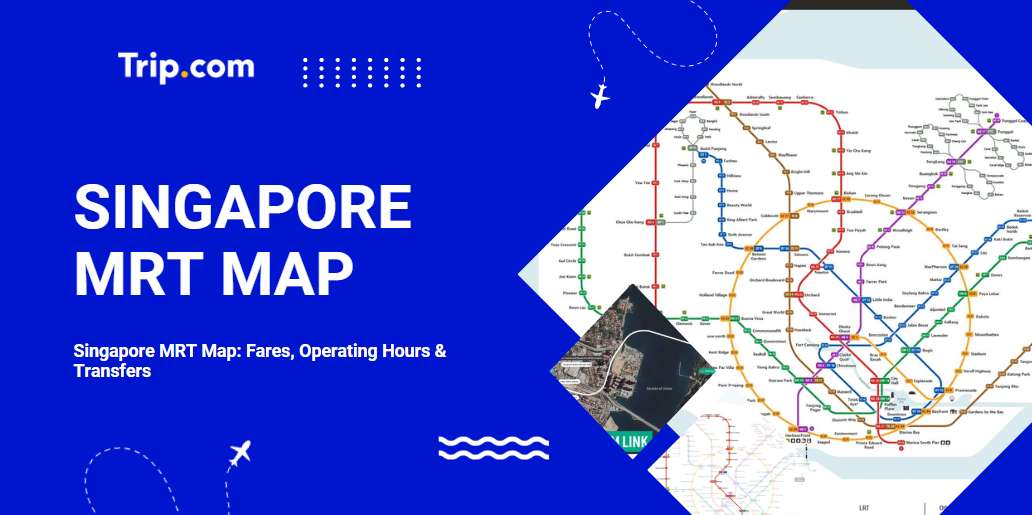
The Singapore MRT is one of the fastest and most convenient ways to explore the city. It’s clean, punctual, reliable, and affordable, offering easy access to all the major hotspots. With just an EZ-Link card or a single-trip ticket, you can zip between shopping districts, cultural landmarks, and scenic parks with ease.
This exclusive MRT guide for tourists in Singapore breaks down the subway map and highlights all the must-visit attractions along each line!

Singapore MRT fares
Singapore MRT fares are calculated based on travel distance and ticket type. They are primarily categorized into adult fares and concession fares for seniors/students. There are also options like the Singapore Tourist Pass, which offers great value and can be used for up to 5 days.
Influencing Factors | Adult Fare (AUD) | Senior / Student Fare (AUD) |
Travel distance | $1.04 – $3.50 | $0.56 – $1.75 |
Ticket Type | Standard Ticket / EZ-Link Card | Standard Ticket / Senior / Student Concession Card |
Ticket Deals | Get 10% off standard adult fares when you tap your EZ-Link card | No discounts |
Singapore MRT Operating Hours
Standard Singapore MRT operating hours:
- First train at most stations: around 5:30 AM
- Last train at most stations: around 12:00 AM
Special adjustments: Operating hours will be extended during New Year's Eve, the eves of public holidays, and major events; please check in advance as operating schedules for certain lines or stations may vary slightly.
Singapore MRT Map
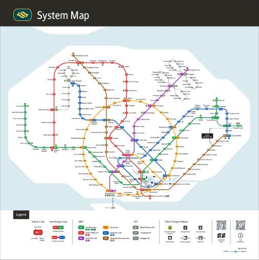
Image credit: Land Transport Authority Singapore
The Singapore MRT map is the heart of the local public transport network, connecting key areas, popular attractions, and residential neighborhoods across the island for fast and efficient travel. Here is a quick overview of the main lines to help you plan your trip.
North-South Line (Red Line)
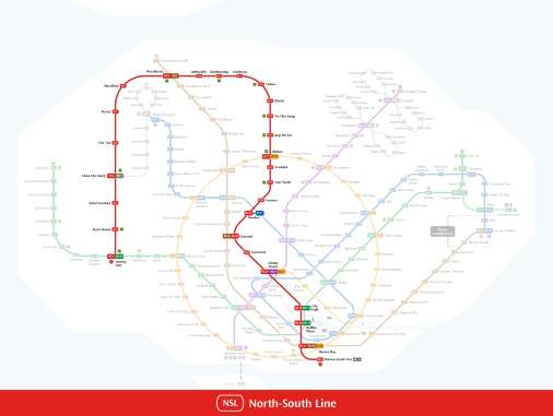
Image credit: Land Transport Authority Singapore
The North-South Line runs from Marina South Pier in the south to Kranji and Woodlands in the north, passing through key stops like Orchard, Dhoby Ghaut, and Bishan. It’s a top choice for reaching shopping districts, the Central Business District, and for transferring to other MRT lines. Each Singapore MRT line is color-coded on the tourist map, making it easy to get around.
Attractions along the North-South Line
Site / Area | Nearby Attractions | Attraction Highlights |
Orchard Road | Orchard Road shopping district | Singapore's iconic shopping street, packed with malls, brand-name stores, and a mix of dining and entertainment experiences |
Raffles Place / Marina Bay | Marina Bay Sands, Merlion Park | Check out Singapore's iconic landmarks, take in the views from the SkyPark, catch the light show, and snap a photo with the Merlion statue |
Dhoby Ghaut | National Museum of Singapore, Fort Canning Park | Singapore's oldest national museum, and a lush hilltop park steeped in history |
Bishan | Bishan-Ang Mo Kio Park | A large city park perfect for picnics, strolls, bike rides, and all kinds of family leisure activities. |
East West Line (Green Line)
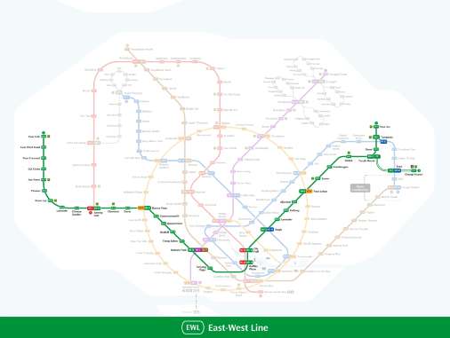
Image credit: Land Transport Authority Singapore
The East-West Line is one of the longest MRT lines in Singapore, stretching from Changi Airport in the east to Tuas Link in the west. It’s a convenient option for airport transfers and reaching attractions like East Coast Park, Bugis, and Jurong East.
Attractions along the East West Line
Site / Area | Nearby Attractions | Attraction Highlights |
Changi Airport | Jewel Changi Airport | An indoor waterfall and lush greenery under a massive glass dome, featuring a mix of shopping and dining. |
Bedok | East Coast Park | Perfect for cycling and enjoying waterfront views, with plenty of seafood restaurants and picnic spots |
Bugis | Bugis Street Market | Score affordable fashion, unique souvenirs, snacks, and bubble tea all in one place |
Jurong East | Science Centre Singapore, Westgate, Jurong Cube | Family-friendly attractions, featuring a collection of malls and an ice skating rink |
Circle Line (Yellow Line)
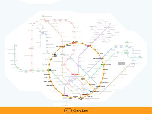
Image credit: Land Transport Authority Singapore
The Circle Line loops around Singapore's city center, connecting areas like HarbourFront, Botanic Gardens, and Paya Lebar. It’s a popular choice for getting around, allowing you to cleverly bypass city center congestion and easily reach key locations.
🚨 Breaking News: The Circle Line Stage 6 (CCL6) officially opened on July 12, 2026, featuring Keppel (CC30), Cantonment (CC31), and Prince Edward Road (CC32) stations. With this, the Circle Line is now fully complete after a 17-year journey.
Attractions along the Circle Line
Site / Area | Nearby Attractions | Attraction Highlights |
HarbourFront | VivoCity, Sentosa Gateway | A massive Singaporean mall that serves as the gateway to Sentosa, Universal Studios, and the beaches. |
Botanic Gardens | Singapore Botanic Gardens | UNESCO World Heritage Site, featuring themed gardens and an orchid garden |
Esplanade – Theatres on the Bay | Esplanade – Theatres on the Bay | An iconic Singaporean arts landmark hosting year-round performances, with stunning views of the Marina Bay skyline. |
Nicoll Highway / Bugis | Haji Lane, Kampong Glam | Filled with street art, unique independent boutiques, and cafes, and don't forget to snap a photo at the Sultan Mosque |
North East Line (Purple Line)
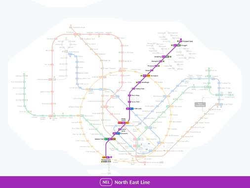
Image credit: Land Transport Authority Singapore
The North East Line runs from HarbourFront to Punggol, passing through stops like Clarke Quay, Chinatown, and Serangoon. It’s the perfect choice for hitting up nightlife hotspots, exploring cultural districts, and checking out vibrant residential neighborhoods.
Attractions along the North East Line
Site / Area | Nearby Attractions | Attraction Highlights |
Chinatown | Chinatown District | Historic streets brimming with Nanyang charm, home to a collection of temples and authentic hawker food. |
Clarke Quay | Clarke Quay | Singapore's nightlife hotspot, featuring riverside dining and scenic river cruises |
Little India | Little India, Mustafa Centre | A vibrant cultural district filled with temples and spice shops, featuring the 24-hour Mustafa Centre. |
Punggol | Punggol Waterway Park, Coney Island | Scenic cycling routes, featuring nature trails and waterfront views |
Thomson-East Coast Line (Brown Line)
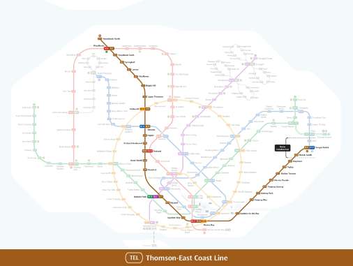
Image credit: Land Transport Authority Singapore
The Thomson-East Coast Line is Singapore's newest MRT line, designed to improve connectivity between the northern, central, and eastern parts of the island, and has been fully operational since 2025. The line passes through key areas such as Woodlands, Thomson, Orchard, Marina Bay, and the East Coast, creating a faster and more convenient travel experience for commuters and visitors alike.
Attractions along the Thomson-East Coast Line
Site / Area | Nearby Attractions | Attraction Highlights |
Woodlands | Woodlands Waterfront | Boasting ocean views and an extra-long pier, with seafood restaurants everywhere |
Orchard Road | Orchard Road shopping district | Singapore's premier shopping belt, packed with malls, cafes, and international brands |
Marina Bay / Gardens by the Bay | Gardens by the Bay | Snap photos at the Supertrees and Cloud Forest, and catch the nightly light show |
East Coast | East Coast Park | Surrounded by beaches and cycling paths, with a variety of waterfront dining options |
Downtown Line (Dark Blue Line)
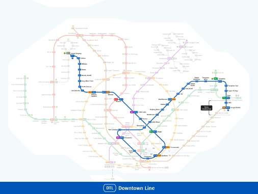
Image credit: Land Transport Authority Singapore
The Downtown Line is one of Singapore's key MRT lines, connecting the eastern, central, and northwestern parts of the island. Spanning 42 kilometers with 34 stations, it is Singapore's longest underground driverless MRT line, offering a more efficient commute for both locals and visitors.
Opened in phases between 2013 and 2017, this line connects major residential areas, commercial hubs, and tourist attractions. It runs entirely underground and is fully air-conditioned, ensuring a comfortable and seamless travel experience.
Attractions along the Downtown Line
Site / Area | Nearby Attractions | Attraction Highlights |
Bugis | Bugis Street Market | A hub for budget-friendly shopping, unique souvenirs, and popular street food |
Little India | Little India neighborhood | A vibrant cultural district in Nanyang, brimming with temples, spice shops, and rich, colorful traditions. |
Botanic Gardens | Singapore Botanic Gardens | UNESCO World Heritage Site, featuring themed gardens and orchid displays |
Beauty World | Bukit Timah Nature Reserve | Packed with diverse hiking trails and rich biodiversity, it’s home to Singapore’s highest peak. |
Singapore's Future MRT Plans
The Singapore MRT network is still expanding, with new lines set to further improve connectivity across the island. With upcoming lines like the Jurong Region Line, Cross Island Line, and the Johor Bahru-Singapore Rapid Transit System, traveling to popular attractions, shopping malls, and nature parks will become even faster and more convenient for visitors.
Jurong Region Line (Turquoise Line)
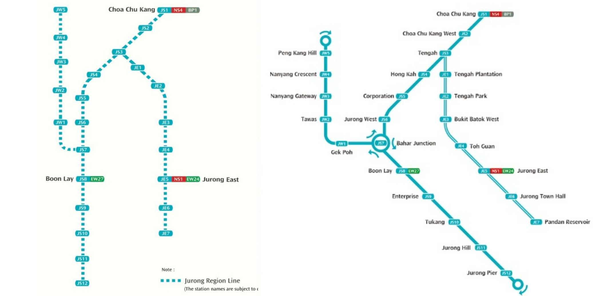
Image credit: Land Transport Authority Singapore
The Jurong Region Line will serve the western part of Singapore, with a focus on areas such as the Jurong Lake District, Tengah, and Nanyang Technological University, significantly enhancing transport convenience for residents, students, and commuters in the west.
🚨 Breaking News: Due to construction challenges, the Phase 1 project of the JR Line has been officially delayed from late 2027 to mid-2028.
Attractions along the Jurong Region Line
Site / Area | Nearby Attractions | Attraction Highlights |
Jurong Lake District | Jurong Lake Gardens | Surrounded by lakeside trails and landscaped gardens, featuring various family leisure areas. |
Jurong Lake District | Science Centre Singapore (New Wing) | A modern science museum filled with interactive exhibits and workshops |
Jurong East | IMM Outlet Mall, Jurong Cube | Enjoy outlet shopping, dining experiences, and ice skating fun all in one place |
Choa Chu Kang | Choa Chu Kang Park | Surrounded by open lawns and fitness areas, a tranquil urban green space |
Cross Island Line (Light Green Line)
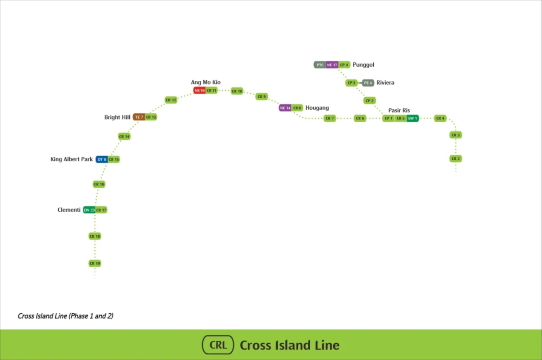
Image credit: Land Transport Authority Singapore
The Cross Island Line is expected to open in 2030, stretching from Changi in the east to Jurong in the west. It will connect the eastern, northeastern, and western parts of the island, providing direct links between nature reserves, residential hubs, and business districts.
Attractions along the Cross Island Line
Site / Area | Nearby Attractions | Attraction Highlights |
Changi | Jewel Changi Airport | Snap photos of the Rain Vortex waterfall and indoor gardens at this one-stop shopping and leisure destination. |
Pasir Ris | Pasir Ris Park, Bugis Junction | Surrounded by waterfront promenades and cycling paths, featuring a wild water park |
Hougang | Hougang malls and residential shopping districts | Packed with local boutiques and cafes, offering a taste of everyday life in Singapore |
Kong Meng San Phor Kark See Monastery | MacRitchie Reservoir | Snap photos at the Treetop Walk and forest trails, and take in the serene lakeside scenery |
West Coast | West Coast Park | Surrounded by cycling paths and children's play areas, with cozy waterfront views |
Johor Bahru-Singapore Rapid Transit System
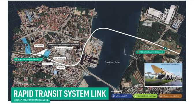
Image credit: MRT Corp
The Johor Bahru-Singapore Rapid Transit System is expected to open in 2027, connecting Woodlands North station in Singapore to Bukit Chagar station in Johor Bahru, Malaysia. This cross-border line will make commuting between the two cities smoother and faster.
Attractions around the Johor Bahru-Singapore Rapid Transit System (Singapore side)
Site / Area | Nearby Attractions | Attraction Highlights |
Woodlands North | Woodlands Waterfront Park | An extra-long pier and sunset ocean views, a natural destination perfect for a leisurely stroll |
Woodlands North | Causeway Point | A large, comprehensive shopping mall that brings together shopping, dining, and entertainment. |
Woodlands (transfer to bus available) | Singapore Zoo, River Wonders | A world-class wildlife park featuring immersive animal habitat experiences |
How do I use an EZ-Link card?
The EZ-Link card is a reloadable smart card in Singapore, perfect for public transit and everyday small purchases. Simply tap it on the reader to pay for MRT and bus fares, or even use it for small transactions at convenience stores and hawker centers. It’s convenient, efficient, and an essential part of daily life for locals in Singapore.
How to use an EZ-Link card
- Where to buy: Available at all subway stations, transit authority ticket offices, and 7-Eleven convenience stores.
- Transit Payment: Tap in and tap out at subway turnstiles and bus card readers. A "beep" sound confirms your payment is successful.
- Balance Inquiry: You can check your balance at subway turnstiles, bus card readers, and self-service ticket machines.
- Top-up methods: You can top up at subway stations, 7-Eleven convenience stores, and self-service kiosks. You can also top up via the EZ-Link official app, which supports auto-top-up features.
Benefits of using an EZ-Link card
- Convenient and worry-free: No need to queue for single-trip tickets, just tap and go;
- Efficient and fast: Tap and go, saving you plenty of time during peak hours;
- Great value: some trips are cheaper than buying tickets with cash;
- Versatile: Beyond transportation, it can also be used for small purchases at vending machines, coffee shops, designated retail stores, and more;
- Easy top-ups: You can add funds through many channels across the island, and the app supports auto-top-up, so you never have to worry about running low on balance.
Trending Searches
-
Popular Attractions
-
Top Flight Routes
-
Popular Hotels
-
eSIM/SIM card
- Forbidden City Tickets
- Universal Studios Japan
- Shanghai Disneyland Fast Pass
- Hutong Beijing
- Tokyo Disneyland Ticket
- Zhangjiajie National Forest Park
- Shanghai Disneyland Ticket
- Taronga Zoo Sydney minisite
- Canton Tower
- Puffing Billy Tickets
- Shanghai Tower
- Summer Palace Beijing
- Universal Beijing Resort
- Yu Garden
- Canggu Bali
- Amritsar to Singapore Flights
- Davao City to Singapore Flights
- Manila to Singapore Flights
- Christmas Island to Singapore Flights
- Bali to Singapore Flights
- Chengdu to Singapore Flights
- Beijing to Singapore Flights
- Nadi to Singapore Flights
- Shanghai to Singapore Flights
- Koh Samui to Singapore Flights
- Malé to Singapore Flights
- Qingdao to Singapore Flights
- New Delhi to Singapore Flights
- Paro to Singapore Flights
- Penang to Singapore Flights
- Swissotel The Stamford Singapore
- Yotelair Singapore Changi Airport
- Hotel Mi Rochor
- Dorsett Changi City Singapore
- Mercure ICON Singapore City Centre
- Dusit Thani Laguna Singapore
- Village Hotel Changi by Far East Hospitality
- V Hotel Lavender
- Hotel Royal Singapore
- Hotel Boss
- Sofitel Singapore Sentosa
- Somerset Bencoolen Singapore
- Hotel Waterloo Singapore - Handwritten Collection
- Aura Hotel Mackenzie
- Park Avenue Clemenceau
- The Hive Singapore Hostel
- Nest Hotel
- Hotel Calmo Bugis
- Singapore Marriott Tang Plaza Hotel
- Duxton Reserve Singapore, Autograph Collection